Elevate 4 finally released
After an extended testing period Elevate 4 has been released today. The map key was also updated.
Downloads as alway on the Elevate page.
Major changes:
- One size only: SVG version which scales with screen density is now default, no more different sizes.
- All graphics are scaleable: all symbols and patterns are now displayed with scalable vector graphics and scale with screen density, instead of pixel based PNG files. For example patterns like those on private roads are now scaled and should be better visible on high density screens.
- Routes: national and international routes have seperate colors (same for hiking and cycling, blue and red, so I had to change regional cycling routes as well), hiking routes colors match now those that are used for hiking routes in some areas. General route rendering has been optimized as well.
- Mountain Bike: seperate MTB map style with rendering of visibility of paths and with new rendering for mtb_scale_uphill
- Locus: Locus version includes now Locus Edition (LE) versions for single language V3 maps and standard Elevate for multilangual V4 maps. All objects scale now much better in Locus LE.
- Access limits: those are filtered now, a way with only private/no access is only rendered as that in hiking (or cycling) mapstyle, if this access limit is also valid for pedestrians (or cyclers). Only the city mapstyle shows general access limits.
- And many more smaller additions and optimizations.
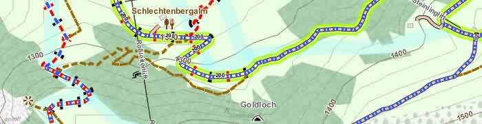
The new MTB map style of Elevate 4
Buongiorno
Scaricato Elevate 4 ma sulle linee di quota non sono indicate le quote.
Cosa bisogna fare?
Grazie
Yes, thats a problem.
The new Version of Elevate is made for the latest Orux – a Orux that is in BETA for Months now without release.
We desperately hope that the Orux update will be finished soon.
Best regards
Christian
Please have a look here:
https://www.openandromaps.org/en/oam-forums/topic/elevate-4-3-3-2-legacy-version-if-you-have-problems-with-elevate-4-4-0