Dear OpenAndroMaps community.

The naming of the OAM maps changes as follows:

1.) From:

  • [name]_ML.map (= the map file itself)
  • [name]_ML.poi (= the POI file for Oruxmaps)

Please delete these files !

2.) To:

  • [name]_oam.osm.map (= the map file itself, appears in the Locus MapManager as [Name Oam])
  • [name]_oam.osm.db (= the POI file for Locus)
  • [name]_oam.osm.poi (= the POI file for Oruxmaps)

As you can see, the long awaited POI files for Locus are now added.
This feature is currently in BETA Test.
If you want to partizipate in the BETA-Test please sign up for the forum (please, use a_real_ EMail Address):
https://www.openandromaps.org/oam-forums/topic/poi-nutzbarkeit-der-dateien-mit-locus/page/7
(mixed German/English)

Please install the maps as before, the POI files will be copied automatically to your mobile device.

If you want to try out the new POIs for Locus you should have a look here,
LOCUS Manual

A clear word: The quality of the original locus poi database is not reached, e.g. the offline location search is missing. If you need this feature you have to purchase the corresponding map in the LocusShop (its cheap) and use the included POI database with the OAM maps (as many users did this in the past)

A video tutorial will follow as soon as the bugs are eliminated.

As Locus has a very good mapsforge support for V4 maps since version 3.38 and doesn’t need a special file structure also, a special Locus version of the map style files isn’t necessary anymore.

Elevate LE, which is necessary for the legacy V3 maps, is still available as separate download on the Elevate page.

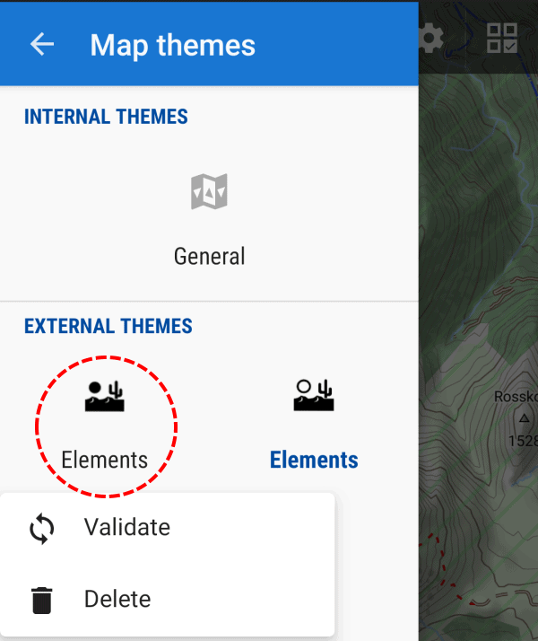
Double Elements: as Elevate now has a new clean file structure, with quick install the old Elements file remains in the theme folder and can still be chosen with the map style choser (in addition to the new version).

This can be solved easily:

  • The simplest way (installations from 03/10/19): just press long on the old Elements icon with the black sun and choose delete (as in the screenshot below)
  • For installations between 30/09/19 and 02/10/19: delete both Elements installation by two long presses on the desert symbols, and install Elevate again via quick install
  • Delete with a file explorer all not needed files in the directory “/Locus/mapsVector/_themes/” on the internal SD card (or which custom theme directory was chosen in Locus); all files and folders with “ele” in the name except the folder “Elevate”; if you delete too much, just use quick install again


For most of you there are no changes ’cause 95% of OpenAndroMaps users already use the multilingual maps.

As already announced some time ago, we are now finally switching to the multilingual maps and drop support for the old V3-Maps. These have been around since 2015/16 and I think that 3 years is sufficient to say goodbye to old specifications and open new resources for new developments.

The development of the Mapsforge vector library is progressing and we would like to share with you the advantages and new features. We are working on a new version of the OpenAndroMaps which will be enhanced and modernized especially in the field of cycle- MTB- and hiking routes.

For this it is necessary to drop old Balast.

The 270 V3 maps will be updated in the next 3 weeks and will be available for download by January 2020.
Of course, the download pages will also be adapted accordingly. For now the separate download button for the POIs will be kept – although the POIs are included in the ZIP archives of the maps.

EndOfLife V3-Karten

Best regards

Team of OpenAndroMaps

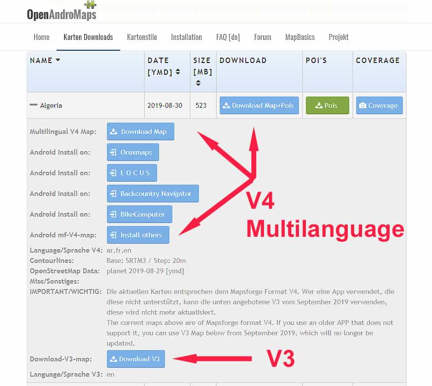
OpenAndroMaps will switch to Multilanguage “V4” Maps mid of 2019.
Single Language “V3” Maps will be updated till July 2019 – so, dear users AND APP-Developers, please switch to V4 maps.

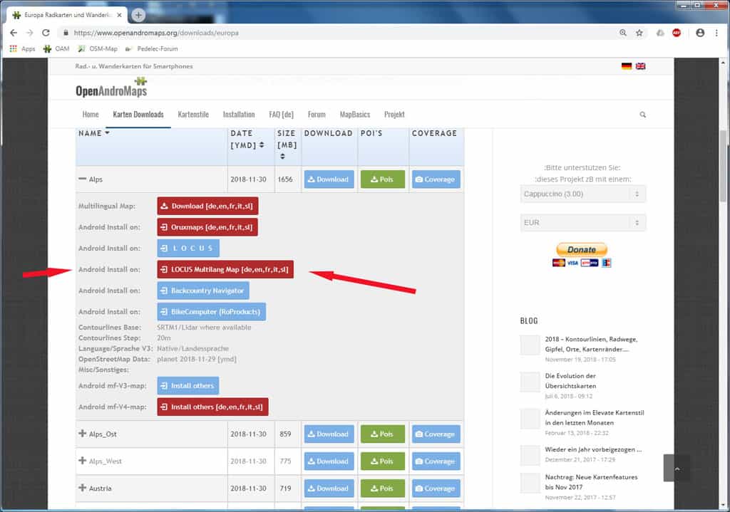
As a service for the big community of LOCUS users OpenAndroMaps now offers a DirectInstallButton for V4 Maps too on the download-pages.
The ony real disadvantage over V3 maps, as I know, is that Locus does not support automatic map switching with V4 maps.

Locus DirectInstall V4 Maps


For two years after the Nov 2016 edition of the world overview maps I have worked on the curation of additional content to be put on top of the variouis background maps for the different zoom levels. Why ? I am a curious traveler to places where “always on” is (still) a lie. In the case of interest in something about a country or region or province, too much jumping back and forth from offline Wikipedia (like Aard2 or Kiwix) is annoyance. So, I put a number of information directly into the world overview maps:
– The capitals of countries, states and provinces of many countries are shown in 3 different colours, in English and local language (if significantly different).
– Islands and archipelagos, in particular the remote ones, are hard to spot on maps – here is remedy by highlighting them, from zoom level 3 up.
– Triggered by an OAM forum discussion about visibility of peaks, and with the help of Max’ algorithm to select, 100s of important peaks are highlighted.
– Also the major ocean deeps are shown.

Some insights into the process: the current MOBAC rendering tool with the Mapsforge library embedded does not provide a proper visibility of labels like settlement names. Even big cities may not show up at all. Using Maperitive in addition allows to take control of the label renditions in a predictable way. Unfortunately, Maperitive has a bug omitting the leftmost or rightmost of a label for a fraction of a label. Playing with scope and zoom around the affected place the missing parts can be added in a manual patch step (at least for the most visible cases like highlighted capitals – I hope I caught those all). Once you go this route, this opens an additional option: make larger settlements dominate the label display in a much more accurate way than the simple city-town-village-… attributes in OSM would allow. Hence now also the size of the settlement labels increases by population (in 11 catagories), if provided in the OSM data set (hopefully correctly!), otherwise a minimum assumption is made for the OSM categories city, town and village. As Maperitive is an OSM tool, this is achieved by amending the original data with categories of population sizes. Those “PopCat” tags are now also embedded in Christian’s OAM maps. They can be used by themes to select (restrict) the settlement names to be displayed. The adaption of the latest Elevate theme is on my list for 2018, but maybe somebody else is faster 🙂

Bottom line: the intent behind all that is to have essential geo information at a finger tip, fully OFFLINE. A sort of companion for Offline Wikipedia. Enjoy!

Michael Bechtold

With the update of the maps next week there are critical changes in the structure of the maps. The difficulties of the mountain paths are rendererd slightly different (the sac_scale).
The renderthemes are now prepared for this change, please install these updated themes.

Link to Tiramisu Theme

Elevate/Elements Theme install

Openandromaps_HC theme

Please update your themes, otherwise the sac_scale of the mountain paths will be rendered wrong !!

Hi,

This is an information for Theme-Composers.
There will be an important change in tag-mapping for the OpenAndroMaps.

Until today sac_scale was preprocessed to carry only 4 levels:
T1,T2,T3 and T4, while T4 included T5+T6 too.

Now sac_scale will be extended for all levels = T1 – T6 (August update), so seperate levels for T1,T2,T3,T4,T5,T6

This includes some minor changes:
DAV_SCALE “black” is transformed to SAC_SCALE=T5 (was T4 so far)
If a way includes any “via_ferrata” tag/value SAC_SCALE is set to “T6” (was T4 so far)

_and_
in a second step (October) raw_sac_scale will be no longer supported = removed from Tag-Mapping!

SO: sac_scale T4 will NO LONGER INCLUDE T5+T6 > T5 AND T6 are seperate values from August update on.
THIS MEANS: You have to extend existing rules for sac_scale=T4 to “sac_scale”=”T4|T5|T6”
AND existing rules for “raw_sac_scale” have to be extended to “sac_scale|raw_sac_scale”

Please prepare your themes.

This have to be made in a 2-step process:

Extend your rules so that sac_scale prozesses T5 and T6 too.
So if you have a rule :

    <rule e="way" k="sac_scale" v="T1">
          <line stroke="#FFAA00" stroke-width="0.65" stroke-dasharray="17,1" stroke-linecap="butt" />
    </rule>
    <rule e="way" k="sac_scale" v="T2">
           <line stroke="#3052FF" stroke-width="0.65" stroke-dasharray="17,1" stroke-linecap="butt" />
    </rule>
    <rule e="way" k="sac_scale" v="T3">
           <line stroke="#FF0000" stroke-width="0.65" stroke-dasharray="17,1" stroke-linecap="butt" />
     </rule>
     <rule e="way" k="sac_scale" v="T4">
           <line stroke="#000000" stroke-width="0.65" stroke-dasharray="17,1" stroke-linecap="butt" />
     </rule>

extend it to:

      <rule e="way" k="sac_scale" v="T1">
          <line stroke="#FFAA00" stroke-width="0.65" stroke-dasharray="17,1" stroke-linecap="butt" />
      </rule>
      <rule e="way" k="sac_scale" v="T2">
          <line stroke="#3052FF" stroke-width="0.65" stroke-dasharray="17,1" stroke-linecap="butt" />
      </rule>
      <rule e="way" k="sac_scale" v="T3">
          <line stroke="#FF0000" stroke-width="0.65" stroke-dasharray="17,1" stroke-linecap="butt" />
      </rule>
      <rule e="way" k="sac_scale" v="T4|T5|T6">
          <line stroke="#000000" stroke-width="0.65" stroke-dasharray="17,1" stroke-linecap="butt" />
      </rule>

from October on you can create additional, seperate rules for T5/T6

If you use a raw_sac_scale, extend the rules:

       <rule e="way" k="raw_sac_scale|sac_scale" v="RT1|T1">
          <some settings..../>
      </rule>
      <rule e="way" k="raw_sac_scale|sac_scale" v="RT2|T2">
          <some settings..../>
      </rule>
      <rule e="way" k="raw_sac_scale|sac_scale" v="RT3|T3">
          <some settings..../>
      </rule>
      <rule e="way" k="raw_sac_scale|sac_scale" v="RT4|T4">
          <some settings..../>
      </rule>
      <rule e="way" k="raw_sac_scale|sac_scale" v="RT5|T5">
          <some settings..../>
      </rule>
      <rule e="way" k="raw_sac_scale|sac_scale" v="RT6|T6">
          <some settings..../>
      </rule>

So everyone making themes for OpenAndroMaps have to ensure that everything renders fine when expanding the sac_scale and finally deleting raw_sac_scale. I know its annoying – however there is no other way to ensure that the maps render fine in future.

Additional TAGS that will be removed from tag-mapping by end of October:

  • raw_sac_scale (as mentioned above)
  • incline_dir
  • class_bicycle_mtb, class_bicycle_road (maybe we find a solution to transform _mtb to existing tags)
  • noexit

I’m terribly sorry about this, however recently I discovered that there is a limit of max. 15 Tags in the MapsforgeWriter per OSM_Object so I have to reduce the amount of tags – otherwise we end up in white tiles rendering the maps at is was the case with parts of upper Austria last weeks.

See discussion of this issue at MapsforgeDevGroup:
https://groups.google.com/forum/?fromgroups=#!topic/mapsforge-dev/kQKfCMGk2Ec

Best regards
Christian
Multilingual maps- what does this mean?

As an example: The OpenStreetMap database provides NAMES for most objects like Citys, Roads, Churches, Rivers, aso.. in different languages. So for the map of Israel usually in hebrew, arabian, english, maybe in german. For maps of Russia usually in russian and english.

Up to now only one language per maps was possible to include and display on our smartphones.
So providing two languages for one maps for OAM meant making –  and for you, downloading two different maps.

With the new, multilingual maps it is possible to include different languages while making the map and switching map-language in an APP – if an APP is compatible with these maps AND provides a language switcher. This is the case for ORUXMAPS and LOCUS for Android and Cruiser for Android + PC.

Here you see a small screencast of ORUXMAPS switching between russian and englich using the map of Moscow:

Orux-Multilingual_Maps_OAM[EN]

So we decided to provide the multilingual maps on OpenAndroMaps.
The effort for providing two different versions of the maps (old single and new multilingual = 250 each) is crazy.
However, we are aware that a lot of APPs still only support the old “V3” single-language maps – and keeping our users in mind we will support both versions for while, as far and long as our resources will allow this.

For now we provide the new multilingual “V4” maps for download to PC AND for direct install to ORUXMAPS. The download/install buttons for these maps are RED, the included languages are shown for each map as abbreviations in square brackets. The new map files itself are identified by a “_ML” suffix.
So, eg., while the name of old map is “Germany.map” the name of the multilingual map is “Germany_ML.map”

For more information klick here

The old maps that we provided in different languages will be available in future only in one language (usually native lang. or english) – this is the case for all russian mapps, several maps for Asia aso. PLUS the multilingual version.

The POI files for the multilingual maps are included in the zip-files of the maps. With the next update of ORUXMAPS these POI-files will be installed in the right place on your Smartphone if chose direct install.


Next posting will deal with the complete redesign of the categorie-structure of the OpenAndroMaps POI-files.

Best regards
Tobias & Christian

Austria and South Tyrol has finished the LIDAR Laserscans and released this dataset to the public for free.
@Sonny converted it to usual hgt files and published it for download:

http://data.opendataportal.at/dataset/dtm-austria
http://data.opendataportal.at/dataset/dtm-german
http://data.opendataportal.at/dataset/dtm-slovenia
http://data.opendataportal.at/dataset/dtm-spain

For the OpenAndroMaps this means that serveral Maps benefit from these new elevation data, and believe me – the difference is incredible.

  • Austria
  • Alps (Austria und South Tyrol)
  • Alps_Ost
  • Italy (South Tyrol)
  • Berlin, RheinlandPfalz
  • Slovenia
  • Spain

I strongly recommend you to update these maps, especially if you are a mountain hikers or MTB enthusiast.

Here in this Thread you can see examples of various tiles [DE]


Soon Elevate 4 will be released, and as there are some major changes I already offered some test versions here. This last test version I make a bit more public, maybe someone can still find some issues. I mainly tested with OruxMaps 6.5+ at 320ppi and Atlas under Windows. I am happy about some feedback, especially with other apps/densities.

Major changes:

  • One size only: SVG version which scales with screen density is now default, no more different sizes.
  • All graphics are scaleable: all symbols and patterns are now displayed with scalable vector graphics and scale with screen density, instead of pixel based PNG files. For example patterns like those on private roads are now scaled and should be better visible on high density screens.
  • Routes: national and international routes have separate colors (same for hiking and cycling, blue and red, so I had to change regional cycling routes as well), hiking routes colors match now those that are used for hiking routes in some areas. General route rendering has been optimized as well.
  • Mountain Bike: separate MTB mapstyle with rendering of visibility of paths and with new rendering for mtb_scale_uphill
  • Locus: Locus version includes now Locus Edition (LE) versions for single language V3 maps and standard Elevate for multilingual V4 maps. All objects scale now much better in Locus LE.
  • Access limits: those are filtered now, a way with only private/no access is only rendered as that in hiking (or cycling) mapstyle, if this access limit is also valid for pedestrians (or cyclists). Only the city mapstyle shows general access limits.

And many more smaller additions and optimizations.

Downloads:

Elevate OruxMaps quick install
Elevate Locus quick install

https://www.openandromaps.org/wp-content/users/tobias/Elevate4.zip
https://www.openandromaps.org/wp-content/users/tobias/Elevate4_Locus.zip