New maps:

  • Guam (Oceania)
  • Samoa (Oceania)
  • Bulgaria in Cyrilic
  • Israel, Syria, Jordan in Hebrew + Arabian

I’m aware that some Islands in the Pacific are missing.
If someone needs these maps just drop me line.

Modified maps:

  • Saarland (Germany) now include Lothringen and Luxemburg
  • Geece: Coverage now include the coast of Turkey – so you need only this map for the whole Aegean see

New features:

  • fords
  • toll roads
  • Incline

New maillist:
Announcing new Mailinglist dedicated for Outdoor Openstreetmap-mappers from Richard:
https://lists.openstreetmap.org/listinfo/outdoor-natural

Update shedule:
European maps are rendered every 4 weeks, all other regions 5-6 times a year

Serverupgrade:
Done without any problems, Server is now capable to withstand minor flooding attacks we exerienced in the past weeks.

Nice walks an cycling with OpenAndraMaps
Christian

The maps theme Elevate 2.0 has been released today with some important changes. Support for high density displays and rendering of cycling routes are included now. The basis for the new sizes are completely reworked and unified symbols which are now used in the standard version, too.

There are three sizes: Elevate for ~160-240dpi, Elevate L for ~320 dpi and Elevate XL for ~450dpi.

Elevate - Elevate L - Elevate XL

Those are available in three variations: Elegant as a light version for cities, Elevate with hiking routes and thick footways and paths on which difficulty and visibility are shown, and Elevelo with cycling routes and ways.

Elegant - Elevate - Elevelo

Thanks a lot for all feedback on the test versions, and especially to Dsvilko for his size changing script which made this a lot easier!

All changes here. The map key has been revised as well, you can find it and the downloads as usual under Legend/Elevate.

Best regards,

Tobias

Hi,

There are is a growing community developing themes for OpenAndroMaps.
Up to now they had to reverse engeneer the settings of the OpenAndroMaps – a very time-consuming and unpleasant task.

So I decided to publish the basic settings (Tag-Transform, TagMapping) of the OpenAndroMaps to make live easier for everyone.

Why in english only?
If you intend to go deeper into theme-composing and rendering you will find that nearly all manuals are written in english.
So there’s no sence to provide German language here while you have to go to english with external sources.

So, if you are interested to spend some time for modifying or composing themes you find basic informations here in the main menu under “MAPBasics”

Best regards, Christian

… so there are fresh maps available for Asia, Ozeania, South-Amerika (and the rest of the world 😉 )

I added some new tags especially for Mounain-Hikers, for this application I recommend the Elevate Theme

Beste regards
Christian

Author: Tobias Kühn

I’m pleased to present a new rendertheme of our new Co-Author Tobis Kühn.
Tobias agreed to present this theme on Openandromaps on his own page:

https://www.openandromaps.org/en/legend/elevate-mountain-hike-theme

The theme is clearly focused on serious Alpine/Mountain hiking.

All weak points/issues of the more general andromaps_hc theme are adressed:
– Ski slopes are rendered more decent
– Better visibility of ways and paths, yet with visible route information
– Better perfomance doe to optimized, clear coding
– Ridges, cliffs, scree, scrub, etc. are rendered much better.
– etc…

For me the decission is clear: This is the theme I will use hiking in the mountains.
The Theme is compatible both for Oruxmaps and Locus.
I strongly revommend to install it on Orux in the folder ../oruxmaps/mapstyles/ELV/

Thanks to Tobias
and
Best regards, Christian

Themes

The new tags/symbols are part of the themes for Oruxmaps with themeswitcher (available as Beta)
-Download-

New/fixed Symbols:

  • mountain_pass=yes
  • amenity=biergarten 😉
  • tower/communication/observation: These tags were already included in the maps. However for some reasons Maspforge hav’nt redered them. So I transform “tower:type” to a value of “tower”, so the tags to render are:
    • tower=communication
    • tower=observation

    This works perfect and helps a lot for hiking in free countryside.

  • Die Cycle Barriers: rendering was brocken so far (my foult, nobody’s perfect ,-) ), now it works fine

Maps

The map of Baden-Württemberg noe includes the whole Vogesen

Pictures of the new symbols:

Best regards, Christian

Orux has released a beta with full functional themeswitcher: http://www.oruxmaps.com/cs/

In short: Its working flawless, no artefakts from previous used theme after switching.
The Openandromaps – Locus Themes with all goodys are working perfect in Orux now.

I will provide the themes in a special directory structure once the new version of Oruxmaps is released in playstore.

EDIT: I’v provided a complete set of the new openandromaps themes with optimized folder structure for download:
www.openandromaps.org/wp-content/files/themes/orux_new/themes_orux_new.zip
Unzip the contents to /oruxmaps/mapstyles/ (dont forget the /patterns /symbols folders) for the switching themes look at the oruxmaps site: http://www.oruxmaps.com/cs/

Its easy, enjoy!

Best regards, Christian

Updates

The summer break is over,  starting with Germany and Europe the regular update scedule is in operation again.

Volker has contributed a very slim general World-Map covering zoom-levels 1-7. The appearance is very fine with decent relief-shading – download it in the Genaral Maps section.

NOTE: There are lots of inprovements with the maps/themes,  please clear the cache of your APP!

Georgia – incl. Armenia, Azerbaijan was flooded by sea so far – this is resolved with the new coastlines-file.

Missing water in Lakes like the Como-See: I constantly try to correct geometry errors in the OSM-Database, the Como-Lake was rendered without water (white),  this should be resolved now (as it was with the Vierwaldstädtersee, the Thunsee aso..).
Unfortunately Mapsforge (the Renderer used for the openandromaps) is very strict concerning geometry errors – so the only way to ensure correct rendering is to constantly resolve errors in OSM.

New/modifiedTags:

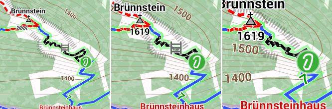
highway=via_ferrata as standalone was not rendered so far.
This issue is resolved, highway=via_ferrata is transformed to  highway=path +  sac_scale=T4 + via_ferrata_flag=set and rendered as via-ferrata (black/white dashed). There is no need for changes with the theme, all transforming is done pre rendering.

Campsite und Motorhome sites now appear from zoom-level 12 on, a most frequently requested feature.

building=terrace and 9 more kinds of buildings added, transformed to “building=yes” – so no changes with the theme are necessary.

Churches, Chapels and Cathedrales are now rendering more reliable (Hikers will love it, it makes navigation easier)

Themes:

natural=forest|wood is rendered with transparent coloring.

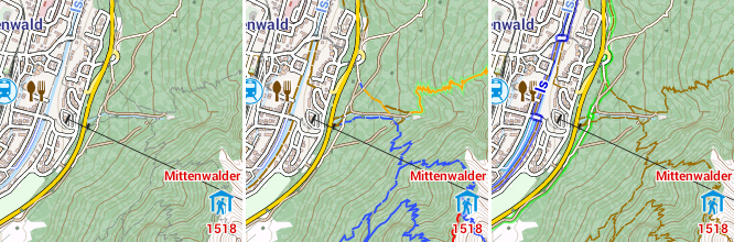
The Captions (names) of rivers are rendered from zoom-level 12 on , streams and canals from level 14

			<rule e="way" k="waterway" v="river" zoom-min="12">
				<pathText k="name" font-style="bold" font-size="18" fill="#3464a5" stroke="#ffffff" stroke-width="2.0" />			
			</rule>
			<rule e="way" k="waterway" v="stream|canal" zoom-min="14">
				<pathText k="name" font-style="bold" font-size="14" fill="#3464a5" stroke="#ffffff" stroke-width="2.0" />			
			</rule>

Experimental: The captions (names) of lakes are now rendered from level 14.
The solution was to calculate the center of the polygon (the lake) and place a node there with the name of the lake. This reders fine for usual geometrys, for ones like extreme “L”or “U”-shapes the names may be rendered outside the lake.

Renderrule:

	<rule e="node" k="natural" v="water">
      <caption k="name" font-style="bold" font-size="14" fill="#3464a5" stroke="#ffffff" stroke-width="2.0"/>
	</rule>

Barriers are now rendered with MTB+HC theme :
(Thanks to Fabrizio)

		<!-- barriers -->
		<rule e="way" k="barrier" v="*">
			<rule e="way" k="barrier" v="fence|wall|city_wall">
				<line stroke="#000000" stroke-width="0.1" stroke-linecap="butt" />
			</rule>
			<rule e="way" k="barrier" v="retaining_wall">
				<line stroke="#888888" stroke-width="0.1" stroke-linecap="butt" />
			</rule>
		</rule>

		<!-- barriers -->
		<rule e="node" k="barrier" v="*">
			<rule e="node" k="barrier" v="bollard" zoom-min="16">
				<circle r="3" fill="#707070" />
			</rule>
			<rule e="node" k="barrier" v="lift_gate|chain|cycle_barrier|stile" zoom-min="16" zoom-max="17">
				<circle r="6" fill="#ff0000" stroke="#00ff00" stroke-width="4" />
			</rule>
			<rule e="node" k="barrier" v="lift_gate|chain|cycle_barrier" zoom-min="18" zoom-max="18">
				<circle r="9" fill="#ff0000" stroke="#00ff00" stroke-width="6" />
			</rule>
			<rule e="node" k="barrier" v="lift_gate|chain|cycle_barrier" zoom-min="19">
				<circle r="14" fill="#ff0000" stroke="#00ff00" stroke-width="10" />
			</rule>
			<rule e="node" k="barrier" v="gate" zoom-min="16" zoom-max="17">
				<circle r="6" fill="#ff0000" stroke="#606060" stroke-width="4" />
			</rule>
			<rule e="node" k="barrier" v="gate" zoom-min="18" zoom-max="18">
				<circle r="9" fill="#ff0000" stroke="#606060" stroke-width="6" />
			</rule>
			<rule e="node" k="barrier" v="gate" zoom-min="19">
				<circle r="14" fill="#ff0000" stroke="#606060" stroke-width="10" />
			</rule>
		</rule>

Rendering of power lines  are now adjusted to zoom-levels:
(Thanks to John)

       <!-- power lines  -->
       <rule e="way" k="power" v="*">
          <rule e="way" k="power" v="line" zoom-max="16">
             <line stroke="#799079" stroke-width="1.3" stroke-dasharray="3,44" stroke-linecap="butt" />
             <line stroke="#799079" stroke-width="0.25" stroke-dasharray="3,7,30,7" stroke-linecap="butt" />
          </rule>
          <rule e="way" k="power" v="line" zoom-min="17" zoom-max="19">
             <line stroke="#799079" stroke-width="0.8" stroke-dasharray="6,65" stroke-linecap="butt" />
             <line stroke="#799079" stroke-width="0.2" stroke-dasharray="6,10,45,10" stroke-linecap="butt" />
          </rule>
          <rule e="way" k="power" v="line" zoom-min="20">
             <line stroke="#799079" stroke-width="0.6" stroke-dasharray="9,88" stroke-linecap="butt" />
             <line stroke="#799079" stroke-width="0.2" stroke-dasharray="9,14,60,14" stroke-linecap="butt" />
          </rule>
          <rule e="way" k="power" v="minor_line" zoom-max="16">
             <line stroke="#799079" stroke-width="1.0" stroke-dasharray="3,32" stroke-linecap="butt" />
             <line stroke="#799079" stroke-width="0.15" stroke-dasharray="3,6,4,4,4,4,4,6" stroke-linecap="butt" />
          </rule>
          <rule e="way" k="power" v="minor_line" zoom-min="17" zoom-max="19">
             <line stroke="#799079" stroke-width="0.7" stroke-dasharray="6,48" stroke-linecap="butt" />
             <line stroke="#799079" stroke-width="0.15" stroke-dasharray="6,9,6,6,6,6,6,9" stroke-linecap="butt" />
          </rule>
          <rule e="way" k="power" v="minor_line" zoom-min="20">
             <line stroke="#799079" stroke-width="0.5" stroke-dasharray="9,64" stroke-linecap="butt" />
             <line stroke="#799079" stroke-width="0.15" stroke-dasharray="9,12,8,8,8,8,8,12" stroke-linecap="butt" />
          </rule>
       </rule>

The new Themes for Oruxmaps are included in the *.zips of the Map-Downloads, the new Themes for Locus are available in the “downloads” + “legend” section and below.

High contrast theme for Locus Cycle/Hike
High contrast theme for Locus MTB
High contrast “light” theme for Locus without Cycle/Hike routes

Last but not least I want to say thanks for all the Bugreports, code snippets, feature requests and – of couse – donations. Thats essential for running and constantly improving the biggest source for free Android vectormaps.

Best regards and pleasant hiking in the Indan Summer
Christian

Its time for a summer break, I’m on tour with MTB and Kajak in the beautifull forrest+lake district in the north of Austria near the border of Czech republic. Unfortunately the 3G-Net is weak in this area 😉
Begining from September on I will update the whole Mapset.

The current update is made with a new set of coastlines – I tried my best to correct errors.
However, if you experience flooded areas please report them – Thanks.

The support will be very basic in the next 3 weeks, if Im sitting at the notebook all the time even during vacance my wife will kill me slowly….

Best regards, Christian

As a fan of Scotland – I’v spent 8 sommers walking in Scotland – I have released a map of Scotland with extreme high details at low zoom-levels. The mapping is the same as for Iceland.
For the lowlands this is in parts a kind of overkill, there you can use the Great_Britain map.

However, for walkers and cyclists able to withstand midges and ocasional showers, walking the Hebrides, the Orkneys, the Shetlands, Skye aso. this map is a great addition to the portfolio.

A great walk in one of the most beautiful nature scenes in Europe
and
Best regards, Christian
… and don’t forget to drink a pint of Guinness to my health …