There is a new version of the Elevate map themes 2.4.

It’s a major update for general map appearance. The goal was to make the map a bit calmer for all those elements which are not so important for hiking/cycling etc. So the colors for inhabited areas, buildings, airports, borders etc. have been toned down. Highway rendering has been overhauled, as well as place names, so that villages and hamlets are easier to distinguish from towns and cities. Many other changes were made to optimize the appearance.

A second major change is the improvements of routes. Local hiking routes now have a separate color (yellow), so it’s easier to follow a regional/local route now. Route refs are more visible.

In the OruxMaps versions the distance of captions to symbols are now larger, so it is possible to use larger variations of the theme on devices with less dpi. Or to resize captions a bit without losing elevation information.

Those and more changes can be found as always in the changelog.

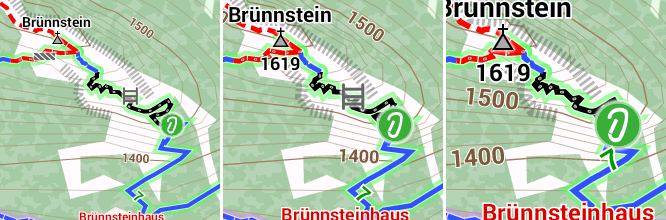
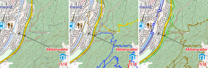
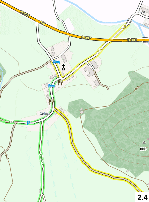
To illustrate the changes in map appearance I attached some comparisons to Elevate 2.3

All downloads can be found as usual on the Elevate theme page, quick installation is highly recommended.

Here are some comparisons to Elevate 2.3:

I’m glad about feedback, for example in the forum here.
News for smaller Elevate updates can always be found here.

Best regards,
Tobias

Here are the new maps for the Eurovelo Cycle Network:

Available Routes for a first glance:

– All pictures of this gallery are property of www.eurovelo.com –

Best Regards,
Christian

Die Openandromaps unterstützen nun die direkte Schnellinstallation auf dem Handy/Tablett ohne PC.

Dies funktioniert sowohl mit Locus als auch mit Oruxmaps.
Sowohl für Karten als auch für die hier angebotenen Themes.

Beste Grüsse
Christian aus der Wachau

The support on Openandromaps.org switches from the WordPress comment system to a customized bbpress forum.
The comment system on the old support pages will be disabled begin of 2015.

I really hope that my efforts to make bbpress compatible with multiple languages will proof stable like it was in the previous testing period.

As usual with all boards a registration is neccessary to prevent the board from spam, as a benefit you will see

  • code formating
  • attachements
  • sorted views
  • new post since last login
  • aso

PLEASE: Do not use disposable EMail-addresses, each registration is checked by Wangguard and its most likely that your registration is rejected without a “real” EMail address.


Once again the SSd on my Rendermachine have to be replaced (100TB written, limit was 75TB for the old 840pro).
The new 850Pro 1TB – approved by Cynthia, the head of of our quality department (as seen on the photo) – will hopefully do the job the whole year 2015 as its specified at 150TB TBW.

Best regards

Christian aus der Wachau

Dear OAM community,

The new mapping with contourlines at low zoom levels is now done for all maps whereever it’s possible.
So navigation is now much easier for all wide, open countrys like Scandinavia, Alaska, South America, Ozeania, Asia und Africa.

NEW MAPS:

1.) Skandinavia
While planing my Austria to NorthCape-Tour for 2015 I’v noticed that there is a map missing for Northern Scandinavia.
So there is a new map available covering all countrys in Northern Scandinavia with extreme high detail level.

2.) France
France map has exeeded the 2GB limit. This means it will not work an all Android devices any more.
So the solution is to devide France into two maps:
– France_North
– France_South
with a wide overlapping between the two maps.
The map covering complete France will be skipped with the next pdate. For me it does’nt make sense to provide a map thats not compatible with all versions of Android.


RENDERTHEMES:

Tobias is constantly improving his “Elevate” theme-family.
It might be a good idea to visit his page on the website and download the latest version of his themes.
www.openandromaps.org/en/legend/elevate-mountain-hike-theme

The changelog for the maps is to be seen here:
www.openandromaps.org/en/map-basics-2/tagtransform
www.openandromaps.org/en/map-basics-2/tag-mapping
So I wish you a pleasant summer and great tours with the OpenAndroMaps, and – maybe – there are some buck left for support of this project 😉

Best regards
Christian

Dear OAM-Community,

As announced three weeks ago there is a new generation of Maps for Android available.
Doe to a new much improved and more flexible prozess of rendering and a better information flow to Tobias wo developed a new subset of his “Elevate” theme we now present better maps for wide, open Countys like Alaska, Iceland, Chile, Argentina, Africa, Oceania…


What’s new:

  • Contourlines now appear at zoom-level 8 providing an overview ways better than bevore
  • Pois for accomodation, water, fords and various other are included at lower zoom-levels

The result (if you use the approbriate themes) is a most improved overview at low zoom levels, the contourlines apply a kind of contour shading from level 8 on.


New, improved Themes:

To get most out of the new maps I strongly recommend to use the Themes from Tobias
These Themes now include

  • Elevate (Mountain hiking)
  • Elegant (Sightseeing in urban areas)
  • Elevelo (Cycle tours)
  • AND NOW: Elements (special made for the new maps, best usage in wide open countrys)


So, how to handle all this:

As an Example: For the outback in Australia use the “Elements” theme – comming to the east coast with their big citys where the Elements provides too much information switch (eg) to the “Elegant”.
Or in Egypt use the “Elements” in the desert and switch to the “Elegant” at Cairo.

Here some Screenshots of the new maps:


There is lots of room for improving the appearence of the new maps during sommer – a slow, steady task we will perform.


Last but not least I want to say thanks for your support an your donations – please keep this project alive, maybe there are some bucks left bevore departing to summer vacation.


We wish you a nice and pleasant summer,
Tobias and Christian


BTW: From now on available with the new mapping: Alaska, Yellowstone_NP, Iceland, Oceania, parts of Asia, Africa, Chile, Argentinia, Peru, Ecuador, Bolivia
Comming soon: British-Columbia, Yukon, remote parts of Russia

New maps:

  • Guam (Oceania)
  • Samoa (Oceania)
  • Bulgaria in Cyrilic
  • Israel, Syria, Jordan in Hebrew + Arabian

I’m aware that some Islands in the Pacific are missing.
If someone needs these maps just drop me line.

Modified maps:

  • Saarland (Germany) now include Lothringen and Luxemburg
  • Geece: Coverage now include the coast of Turkey – so you need only this map for the whole Aegean see

New features:

  • fords
  • toll roads
  • Incline

New maillist:
Announcing new Mailinglist dedicated for Outdoor Openstreetmap-mappers from Richard:
https://lists.openstreetmap.org/listinfo/outdoor-natural

Update shedule:
European maps are rendered every 4 weeks, all other regions 5-6 times a year

Serverupgrade:
Done without any problems, Server is now capable to withstand minor flooding attacks we exerienced in the past weeks.

Nice walks an cycling with OpenAndraMaps
Christian

The maps theme Elevate 2.0 has been released today with some important changes. Support for high density displays and rendering of cycling routes are included now. The basis for the new sizes are completely reworked and unified symbols which are now used in the standard version, too.

There are three sizes: Elevate for ~160-240dpi, Elevate L for ~320 dpi and Elevate XL for ~450dpi.

Elevate - Elevate L - Elevate XL

Those are available in three variations: Elegant as a light version for cities, Elevate with hiking routes and thick footways and paths on which difficulty and visibility are shown, and Elevelo with cycling routes and ways.

Elegant - Elevate - Elevelo

Thanks a lot for all feedback on the test versions, and especially to Dsvilko for his size changing script which made this a lot easier!

All changes here. The map key has been revised as well, you can find it and the downloads as usual under Legend/Elevate.

Best regards,

Tobias

Hi,

There are is a growing community developing themes for OpenAndroMaps.
Up to now they had to reverse engeneer the settings of the OpenAndroMaps – a very time-consuming and unpleasant task.

So I decided to publish the basic settings (Tag-Transform, TagMapping) of the OpenAndroMaps to make live easier for everyone.

Why in english only?
If you intend to go deeper into theme-composing and rendering you will find that nearly all manuals are written in english.
So there’s no sence to provide German language here while you have to go to english with external sources.

So, if you are interested to spend some time for modifying or composing themes you find basic informations here in the main menu under “MAPBasics”

Best regards, Christian

… so there are fresh maps available for Asia, Ozeania, South-Amerika (and the rest of the world 😉 )

I added some new tags especially for Mounain-Hikers, for this application I recommend the Elevate Theme

Beste regards
Christian