- AuthorPosts
- August 19, 2017 at 21:59 #19474
Piotr
ParticipantHi,
for the Poland region, the hiking trails/bike roads are not very usable. They all have the same colour and have weird names.
Here are two examples:
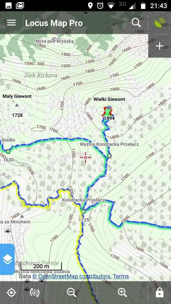
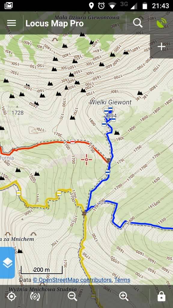
OpenAndroMap – Elevate/Hiking
OpenAndroMap – Elevate/Cycling
Here is a different compilation – where trails have different colors and are easily readable. Is it possible to achieve something like this with OpenAndroMaps?
 August 19, 2017 at 22:34 #19481
 TobiasKeymaster
The colors of hiking/cycling routes and path difficulty use different classifications than the local one in Poland, so the relevant data isn’t contained. See also here:
https://www.openandromaps.org/en/oam-forums/topic/oruxmaps-poland-map-and-trails-coloursIt’s as usable as in every other country on earth :-). Just with a different map key/colors than local ones (as in most other countries on earth).
Developer of Elevate mapstyle
August 19, 2017 at 23:19 #19483Pat100
ParticipantAre you able to try the Tiramisu-2 Style/ Rendertheme?
I am using the free “Vectorial Map Lite” app and find that it works best for me.
I did hack the xml file in the Style’s zip folder to darken the paths and contours (and remove bus stops)
I doubt that it will be ideal for you but if it works it might give you some ideas.
https://tartamillo.wordpress.com/tiramisu/
My hacked (very inexpertly) version is here:
http://www.haggistogo.com/public/thickestbluebusfarm.zip
Regards, Pat.August 20, 2017 at 11:39 #19489ParticipantThe colors of hiking/cycling routes and path difficulty use different classifications than the local one in Poland, so the relevant data isn’t contained. See also here:
https://www.openandromaps.org/en/oam-forums/topic/oruxmaps-poland-map-and-trails-coloursI’m not sure if I understand. Do you mean there is not enough data in OSM to show trail colours, or that OpenAndroMaps is not using that data (and is instead using other data like trail difficulty, which is not available for Poland OSM)?
If it’s “not enough data in OSM” – are you certain? For example osmapa.pl is also using OSM and they show trail colours. For example the same region as the link you gave: http://osmapa.pl/#lat=49.4111&lon=20.4182&z=15&m=os
Also the alternative screenshots from my first post were from a different compilation of OSM (this http://www.gmaptool.eu/pl/content/locus-polska-osm).
Are they using some additional data to display trail colors?I thought in every country trails have some colors in reality. So that when you see a trail mark, it is blue/green/red etc.
Are you able to try the Tiramisu-2 Style/ Rendertheme?
Thank you, I will give it a try later.
August 20, 2017 at 20:35 #19496TobiasKeymasterOpenAndroMaps don’t contain all OSM data, you have to define which is included. Something like hiking route relations is also pretty complicated to process, so Christian only resolves the standard classifications – international, national, regional and local routes. Those are available in Poland, too, as well as trail difficulty. There are links to the corresponding information in the Elevate map key. So using a different theme like Tiramisu won’t help, the map data you’re looking for isn’t included.
Most countries I know don’t have a color system like the Polish one. More often colors are a regional thing or not systematic at all. The colors used in Elevate correspond to some systems in Europe where hiking routes are classified in regional/national etc., but this also depends, and is quite often not used for marking the routes. Trail difficulty colors for mountain hiking are the same as are used in the eastern Alps and are also shown in your screenshot – blue easy, red medium (plus black hard, yellow valley trails).
Developer of Elevate mapstyle
August 20, 2017 at 21:19 #19500ParticipantSomething like hiking route relations is also pretty complicated to process, so Christian only resolves the standard classifications – international, national, regional and local routes.
What are the “route relations”? Do they define trail colors? I thought color is a simple classification and does not need special resolving…
Those are available in Poland, too, as well as trail difficulty.
I think there is no official traill difficulty classification in Poland. (Although maps mark dangerous places, it is not related to the trail). So if OSM contains trail difficulty classification, it”s subjective choice of OSM editors (or it’s completely random…))
So using a different theme like Tiramisu won’t help, the map data you’re looking for isn’t included.
OK I see, thanks.
Most countries I know don’t have a color system like the Polish one
Interesting. So when two trails with the same difficulty cross, they have the same markings? How do you know which one to follow?
August 20, 2017 at 21:51 #19502TobiasKeymasterRoute relations: the route data is stored in relations which combine all the different trail parts – so the colors are not stored every path, bridge, road etc, but in a relation. This can’t be used in mapsforge format, as relations are not supported. So these have to be processed so that every detail is stored in every path, bridge etc.
Trail difficulty: OSM uses the swiss SAC scale for mountain hiking, see http://wiki.openstreetmap.org/wiki/Key:sac_scale
So while not official, it’s a pretty good standardized way. And in the end everything is kind of subjective, OSM and official classifications.Markings: there are lots of possibilities, like a symbol (activate waymarks overlay in Elevate hiking mapstyle), a separate route color, a reference (like E5) or, as with most mountain hikes here, the name of the peak/hut/setllement. Or one could use a map 😉
Developer of Elevate mapstyle
November 2, 2017 at 11:01 #20830Interaktiv Grafika
ParticipantOpenAndroMaps don’t contain all OSM data, you have to define which is included. Something like hiking route relations is also pretty complicated to process, so Christian only resolves the standard classifications – international, national, regional and local routes. Those are available in Poland, too, as well as trail difficulty. There are links to the corresponding information in the Elevate map key. So using a different theme like Tiramisu won’t help, the map data you’re looking for isn’t included.
Most countries I know don’t have a color system like the Polish one.
Hi Tobias,
This system based on the Czech hiking markers system, and it is definitely used in Hungary, Slovakia, Czech Republic, Poland in Central Europe and according to this article probably in other countries as well. In this system people think about route colours coming from the waymarks, so a way with blue crosses is the “blue trail”, one with yellow bars is the “yellow trail” and so on. Luckily mappers in these countries put these colours into the osmc:symbol=waycolor part properly.
Unfortunately this network class system coming through OAM is irrelevant in this case and can be even confusing when it uses the same colour as the waymarks, like colouring a way to green that should be yellow based on the waymarks’ foreground colour.
Of course this network colouring can be changed in the theme (for some people) or be turned off but the problem is that the way colour isn’t coming through. Wouldn’t be possible that just like you read the network tag from hiking routes and attach to ways as hknetwork=“value”, to read the osmc:symbol=waycolor part (if there’s any) and to attach as osmc_waycolor=“value” or something similar to the ways at the same time? Then even just this coming through would be help, theme creators/modifiers could take care of it.Thanks and best regards,
IGNovember 2, 2017 at 20:48 #20838 ChristianKKeymaster
Hi IG,
There are two problems for including the osmc:symbol=waycolor:
1.) These tags are assigned to the Relations and not tagged in the ways. Mapsforge cant resolve these relationships. It is possible to inherit tags from relations to ways by scripting – however this is a extreme time consuming task.
2.) The limit for the amount of tags for a way/node in MapsForge ist 15. Recently we had to remove several tags from tagmapping and redesign the tagmapping to resolve this problem that result in white map-tiles.
So adding another tag to ways will be critical.I will take a look at this issue.
However, for me it should be OK to have OSMC Waymarks, way-names, way-refs aso.Best regards
ChristianNovember 3, 2017 at 13:03 #20844TobiasKeymasterAs Christian wrote (and I did, too), it’s not so easy to include this data. So Christian has to try. But there a some things I still like to address:
This system based on the Czech hiking markers system, and it is definitely used in Hungary, Slovakia, Czech Republic, Poland in Central Europe and according to this article probably in other countries as well.
That doesn’t contradict what I wrote – of the more than 190 states on Earth, the vast majority uses other systems. The people who invented the routing categories in the OpenStreetMap didn’t adapt any national system like the Czech markers, as it only would make sense in the countries it’s actually used. But categories, which can be used and make sense on the whole planet. So calling it irrelevant or other things is not very open minded 🙂
The Wikipedia article is also not very correct, it lists countries like Austria or Switzerland which are using (mainly) different systems, so I don’t know about the validity of the other claims. Looking at this, most countries that use something based on the Czech markers also have their own varieties:
http://www.era-ewv-ferp.com/fileadmin/_migrated/content_uploads/ENG_WAYMARKING_2013_web.pdfIn this system people think about route colours coming from the waymarks, so a way with blue crosses is the „blue trail“, one with yellow bars is the „yellow trail“ and so on. Luckily mappers in these countries put these colours into the osmc:symbol=waycolor part properly.
Unfortunately this network class system coming through OAM is irrelevant in this case and can be even confusing when it uses the same colour as the waymarks, like colouring a way to green that should be yellow based on the waymarks‘ foreground colour.There is only a limited amount of strong colors, so of course a different system might use the same colors. Yes, it can be confusing if you expect the local colors to be shown. But think it from a different perspective: a tourist, which is used to Elevate/OAM style hiking routes at home, might be pretty confused in Poland/Czech Republic/Namibia/Vietnam/… by the local system, and is happy to have maps which he is used to. Or someone who hikes an international trail like the E3 – it makes no sense to him to have all local colors correctly marked in the map, when he can’t see the main route he is following.
So we will see if Christian can implement the route colors, but till then it would be nice if you could appreciate that there are different ways to mark a trail which are just that – different. No need for pejorative language.
Developer of Elevate mapstyle
November 4, 2017 at 09:28 #20861ParticipantAs Christian wrote (and I did, too), it’s not so easy to include this data. So Christian has to try. But there a some things I still like to address:
This system based on the Czech hiking markers system, and it is definitely used in Hungary, Slovakia, Czech Republic, Poland in Central Europe and according to this article probably in other countries as well.
That doesn’t contradict what I wrote – of the more than 190 states on Earth, the vast majority uses other systems. The people who invented the routing categories in the OpenStreetMap didn’t adapt any national system like the Czech markers, as it only would make sense in the countries it’s actually used. But categories, which can be used and make sense on the whole planet. So calling it irrelevant or other things is not very open minded

The Wikipedia article is also not very correct, it lists countries like Austria or Switzerland which are using (mainly) different systems, so I don’t know about the validity of the other claims. Looking at this, most countries that use something based on the Czech markers also have their own varieties:
http://www.era-ewv-ferp.com/fileadmin/_migrated/content_uploads/ENG_WAYMARKING_2013_web.pdfIn this system people think about route colours coming from the waymarks, so a way with blue crosses is the „blue trail“, one with yellow bars is the „yellow trail“ and so on. Luckily mappers in these countries put these colours into the osmc:symbol=waycolor part properly.
Unfortunately this network class system coming through OAM is irrelevant in this case and can be even confusing when it uses the same colour as the waymarks, like colouring a way to green that should be yellow based on the waymarks‘ foreground colour.There is only a limited amount of strong colors, so of course a different system might use the same colors. Yes, it can be confusing if you expect the local colors to be shown. But think it from a different perspective: a tourist, which is used to Elevate/OAM style hiking routes at home, might be pretty confused in Poland/Czech Republic/Namibia/Vietnam/… by the local system, and is happy to have maps which he is used to. Or someone who hikes an international trail like the E3 – it makes no sense to him to have all local colors correctly marked in the map, when he can’t see the main route he is following.
So we will see if Christian can implement the route colors, but till then it would be nice if you could appreciate that there are different ways to mark a trail which are just that – different. No need for pejorative language.
Hi Tobias,
I didn’t want to contradict anything or to use language sounding pejorative, I just described the situation in a couple of countries to extend the original post of this thread. Yes, you described the use case when having some extra indication of international routes is useful: when you want to be sure that you are on a trail leading to the other country. But when you are there or you are a local hiker you care about the waymarks painted to trees, that’s why they are on every digital (and paper) hiking map. So having the routes coloured to the waycolor is just a nice visual bonus to see the routes easier in countries where it makes sense, that’s all. If you can’t do it for some technical reason like extra processing time or tag overloading of the ways it’s perfectly fine, nobody expects you to have extra hardship because some visual extra for a couple of countries. One can turn the network hierarchy colouring of if it seems to clash with waymarks and OpenAndroMaps remain still nicely useful. (Or can even use other maps where waycolor is coming through like LoMaps that on the other hand omit other tags like trail_visibility. It’s all about priorities.)
Thanks and best regards,
IGNovember 5, 2017 at 10:37 #20866ChristianKKeymasterHi IG,
I’m pretty shure that I will manage to include OSMC_COLOR for hiking ways in December update.
… if the tag exists in OSM and its named right according OSM standard tagging
= osmc:symbol / in the waycolor section transformed to osmc_color=If the waycolor is coded in non standard way in some non standard tag it will be ignored.
taging and possible values (more can be added):
<osm-tag key='osmc_color' value='wmco_blue' zoom-appear='13' />
<osm-tag key='osmc_color' value='wmco_yellow' zoom-appear='13' />
<osm-tag key='osmc_color' value='wmco_green' zoom-appear='13' />
<osm-tag key='osmc_color' value='wmco_red' zoom-appear='13' />
<osm-tag key='osmc_color' value='wmco_black' zoom-appear='13' />
<osm-tag key='osmc_color' value='wmco_white' zoom-appear='13' />
<osm-tag key='osmc_color' value='wmco_purple' zoom-appear='13' />
However, implementing this in the existing Elevate/Elements Theme is not an easy task cause if it would be added simply by a switch in the hiking style like “# OSMC waycolors” it would mean that the user would have to turn off both OSM waycolor switches – and I’m pretty shure (for 99%) that this would lead to heavy confusion.
@Tobias ?best regards
ChristianNovember 6, 2017 at 00:04 #20876ParticipantHi Christian,
This is great news. Thanks for experimenting with this option. A question: what happens when a way is a member of more than one hiking routes? It seems like the network-based colouring is using the higher network value in the hierarchy, for e.g. when one route is regional and the other’s local, it’s coloured as a regional way. What happens when these two routes also have different waycolors because for e.g. their waymarks are red_cross and yellow_bar?
Regarding the theme UI, well I roll my own theme so I take care of it 😉 but of course for normal users the official theme should provide a clear way to use it. This Mapsforge theme system has a very simple id-based option handling with check boxes so it can be tricky. I think with a logical hierarchy like
☑️ hiking routes
☑️ …using waymarks colour…it would be clear what happens when both are selected or the first one or neither of them. It would go wrong when only the second one selected. If two same-level options would be used like
☑️ hiking routes (network-based)
☑️ hiking routes (waymarks-coloured)…then the logical problem would occur when both are selected. Well…
Anyways thanks again for evaluating this option.
Best regards,
IGNovember 6, 2017 at 13:13 #20878TobiasKeymasterHowever, implementing this in the existing Elevate/Elements Theme is not an easy task cause if it would be added simply by a switch in the hiking style like „# OSMC waycolors“ it would mean that the user would have to turn off both OSM waycolor switches – and I’m pretty shure (for 99%) that this would lead to heavy confusion.
Yes, I also see it as problematic. I have some ideas, but these have to be tested.
There’s also the problem if a way has several routes with different colors, as IG wrote above. Would it be possible to create something like osmc_color2=wmco2_blue etc.? But there’s the 15 tag limit again…
I also remember that you ran in some problems when introducing the waymark symbols when using the original ways instead of the calculated nodes that are now in use, so maybe try something like alps first.
@Interaktiv Grafika – the most striking difference to the countries I’m used to might be “they are on every digital (and paper) hiking map”, here the colors used on waymarks aren’t usually used on the maps specifically. E.g. every hiking route is marked red on the map, no matter what the waymark is colored.
Developer of Elevate mapstyle
November 7, 2017 at 12:13 #20894ChristianKKeymasterwhat happens when a way is a member of more than one hiking routes
Thats the problem..
Including all colors of a way that contain multiple relations is cumbersome and takes ages in preprozessing.I once started to solve this “issue” and failed.
I will try this one more time this winter.Best regards
Christian - AuthorPosts
- You must be logged in to reply to this topic.