Tagged: aboriginal_lands, boundary
- AuthorPosts
- June 5, 2019 at 17:35 #29185
Viajero Perdido
ParticipantHi.
OSM recently approved a new tag, boundary=aboriginal_lands, and I’m already seeing it well-used in my area. I’m wondering, does OAM support this, or if not, would you consider adding support for it?
It’s very useful to know these boundaries, as those lands are generally access=no for the rest of us.
Thanks for considering this, and for your excellent works as always.
June 5, 2019 at 21:29 #29193 TobiasKeymaster
I also think that would be a useful addition. It’s not contained in the maps, as everything has to be put in tag-mapping to be able to be rendered. So Christian has to add it first and generate the relevant maps, then I can render it with a future Elevate version.
Developer of Elevate mapstyle
1 user thanked author for this post.
June 6, 2019 at 04:15 #29221ParticipantPS, examples here (Alberta, Canada):
https://www.openstreetmap.org/#map=11/52.8331/-113.4603Thanks,
VPJune 7, 2019 at 06:35 #29275 ChristianKKeymaster
Hi,
boundary=aboriginal_lands will be added to OpenAndroMaps with the June update except for Europe (maps are already made).
@Tobias: Prozessing is the the same as for natural parks:
Poly_Label for names
relation = type boundary to MP (there are a lot relations for this tag)I will render map of Dakota for testing.
Best regards
Christian2 users thanked author for this post.
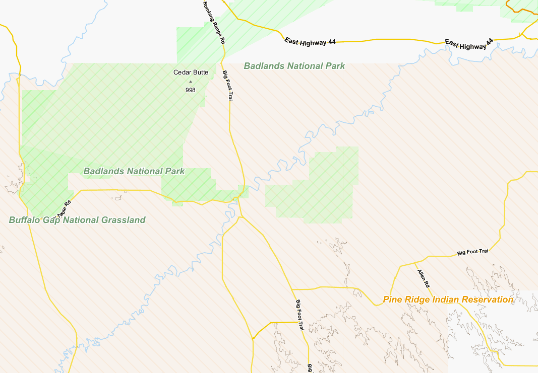
June 8, 2019 at 06:27 #29299ChristianKKeymasterDakota map ist online for download and testing
The date of the map on the download page is the old one – the map is new.June 8, 2019 at 13:28 #29309TobiasKeymasterWorks well, similar rendering as national parks:
Might need some more testing with other maps.
Developer of Elevate mapstyle
2 users thanked author for this post.
June 12, 2019 at 22:27 #29466TobiasKeymasterThe new Elevate 4.3.1 version shows now aboriginal lands (with the new maps).
Developer of Elevate mapstyle
2 users thanked author for this post.
September 10, 2021 at 06:28 #44711ChristianKKeymasterAs for aboriginal_lands:
To all those guys producing monster relations with this tag (esp. in Canada): I will remove these Relations in future unless someone splitt those. Its impossible to render Canada maps with these monster-relations.
September 12, 2021 at 18:19 #44746ParticipantBy “monster”, do you mean, huge number of members, or huge geographical area? If you can point out an example or two of problematic relations, I can try to pass the message along. Thanks.
- AuthorPosts
- You must be logged in to reply to this topic.