- AuthorPosts
- July 14, 2016 at 16:32 #10950
Straker
ParticipantHello everyone!
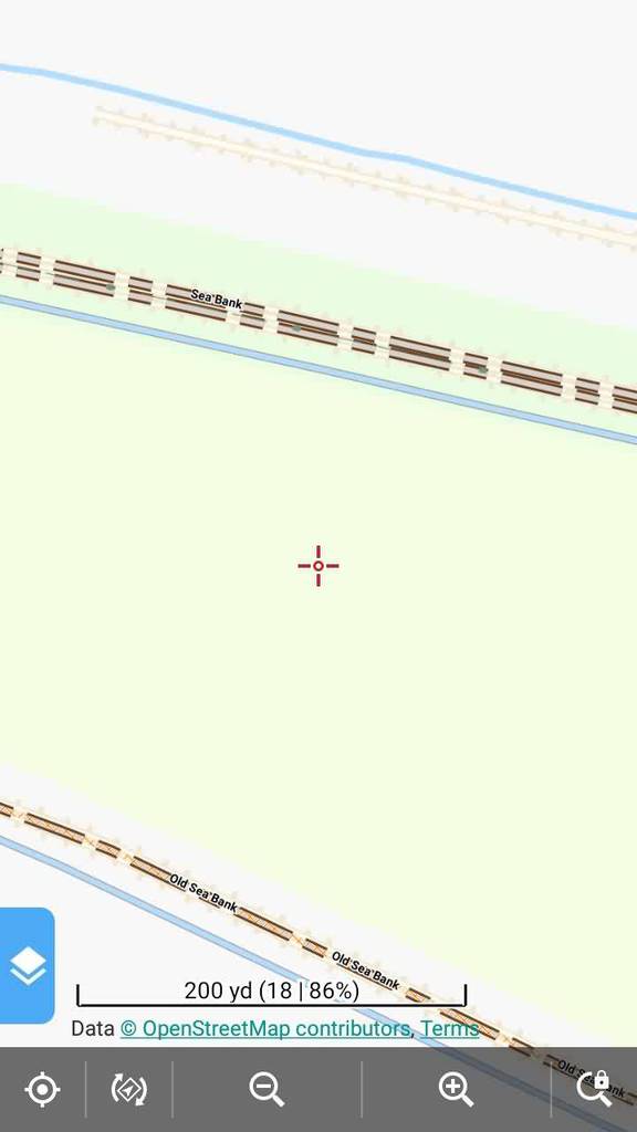
Do you know whether it is possible to display embankments (dykes) on openandromaps? It would be useful, especially where hiking/cycling tracks are on the top.
Regards,
AdamJuly 14, 2016 at 22:24 #10955 TobiasKeymaster
man_made=dyke and man_made=embankment are included in the maps (see here) but not yet shown with Elevate, maybe some other theme. The tracks on top are shown of course.
Developer of Elevate mapstyle
October 5, 2016 at 11:43 #13308 JohnPercyParticipant
In the latest release of Elevate, man_made=”embankment” and man_made=”dyke” are rendered.
However as as far I can see from https://wiki.openstreetmap.org/wiki/Key:embankment:
– embankment=”yes” (transformed in OAMaps to embankment=”emb_yes”) is a considerably more common tag and probably ought to be rendered
– man_made=”embankment” is probably intended to micromap one side of the slope with the left-hand side of the way being the high side and ought to be rendered as such (except, perhaps when a highway, railway or waterway runs along it which might indicate a different intent)
– man_made=”embankment” is not an area tag and so embankments which are closed ways ought not to be rendered. Even if the embankment is mapped as a closed way, for example for the bank of a hill fort, the direction of closed ways in OAMaps seems not to always match the original mapping and so the direction of the slope is as likely to be wrong as right..
– man_made=”dyke” is not clearly documented so it is difficult to know how to interpret this. Perhaps depending on whether a highway, railway or waterway runs along it?
At least that’s how it seems to me at present! I’m working on a version of the Voluntary theme that does this and attach a provisional version.Voluntary and Velocity themes - https://voluntary.nichesite.org
October 5, 2016 at 17:52 #13319TobiasKeymasterHi John,
thanks for your comments. You’re right, I forgot to add embankment=yes.
man_made=embankment: I don’t always follow the wiki, as the actual sometimes differ. But also the Wiki says “When micro-mapping…” to use two ways, else only one. But it’s not possible to know for rendering if someone has micro-mapping in mind and if not, and it’s used in both ways. I’ll check again the data if it really always is used for only one side of a raised bank, then it makes sense to use dy on it.
It’s also quite often used closed, thanks for the hint, and it makes sense to add an adequate rendering for that as well, also it says otherwise in the Wiki (as OSM-carto isn’t rendering it). It’s also quite logical for me to use a closed way instead of an open one for a closed area.
As I’m more attached to the mountains, I’m not that familiar with those stuff 🙂
Best regards,
TobiasDeveloper of Elevate mapstyle
October 5, 2016 at 22:26 #13332JohnPercyParticipantReading the Wiki and comments on Github, I think the approach can either be
– embankment=”yes” should be rendered as the centre line of an embankment and man_made=”embankment” is used as a micromapped single slope of an embankment
or
– if a highway or railway or waterway is tagged as an embankment with either tag, then that is treated as a centre line of an embankment; otherwise both tags are treated as micromapped single slopes.
I guess you are right that it is a good idea to look at the actual data.(“When mapping a highway, railway or waterway on top of an embankment tagging the way with embankment=yes is an obvious choice. If you want to tag the embankment as an own feature however, you may use man_made=embankment on a separate way on each side of the other way.” – Wiki)
As I said above, at least for embankments, the direction of a closed way does not seem to be preserved in OAMaps which means the direction of the slope of an embankment is lost. This means the mapping of, for example, the banks of an ancient hillfort is mangled (unless the closed ways are broken apart as suggested in the Wiki).
Voluntary and Velocity themes - https://voluntary.nichesite.org
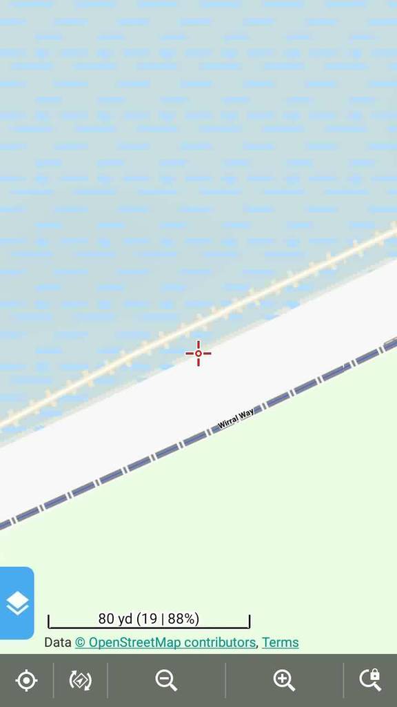
October 6, 2016 at 10:24 #13345ParticipantI would suggest changing of embankments’ color scheme. Frankly, I downloaded the latest Elevate and at first didn’t notice any changes and I was in a room. In full sunlight embankments and dykes are almost totally invisible. Greyish – darker than lighter – tones would be appreciated.
October 6, 2016 at 10:29 #13347TobiasKeymasterI tested stronger colors but they stand out too much, I think it’s more important to see paths/roads at a first glance. So embankments/dykes are rendered like other minor landscape features pretty light, it makes sense to reserve high contrast and stronger colors for important features.
It also depends on your device/screen if you can see it well. For me it works.Developer of Elevate mapstyle
October 8, 2016 at 00:01 #13456JohnPercyParticipantIt does rather depend on the background as to whether the embankment is visible with the colour Tobias has chosen in his themes
Voluntary and Velocity themes - https://voluntary.nichesite.org
October 8, 2016 at 14:14 #13494TobiasKeymasterAfter John suggestions and reading/testing I’ll use a different rendering in the next update, maybe it will work better for you, see the attached screenshot.
Developer of Elevate mapstyle
October 10, 2016 at 16:35 #13659JohnPercyParticipant@Tobias: I think your rendering of embankments that are closed ways is still incorrect. You have moved the ticks to the other side of the line, in effect reversing the direction of the slope which is no improvement as the direction of the way is lost in OAMaps. I suspect all closed-way embankments are drawn clockwise in OAMaps, regardless of how they are mapped.
Voluntary and Velocity themes - https://voluntary.nichesite.org
October 11, 2016 at 19:35 #13698JohnPercyParticipant@ChristianK: I suspect all closed-way embankments are drawn clockwise in OAMaps, regardless of how they are mapped.
Can you please advise? Is that the case? Is it unavoidable?Voluntary and Velocity themes - https://voluntary.nichesite.org
October 11, 2016 at 20:27 #13700TobiasKeymasterI think every closed way is drawn clockwise in mapsforge maps, I don’t know if there is any way to prevent this. I just checked with building and added the same ticks as in embankments, all have the ticks “outside”.
But all closed embankments I came upon make more sense this way (to be above the ground instead below), have you any examples where a “hole” is marked? I haven’t found a good way to find closed ways with overpass turbo, so it’s pretty hard to find the right data.
Developer of Elevate mapstyle
October 12, 2016 at 09:37 #13721JohnPercyParticipantStrangely, it turns out that the only example I can find like this is the one I have been looking at, right on my doorstep: Hunsbury Hill fort at 52.21857383856058,-0.9201154867529926 http://www.openstreetmap.org/way/254062394 which has a ditch around it. In the current OAMap this is represented by two closed ways. In general an old hillfort, as in the wiki example, has a circular embankment, so one way is drawn clockwise and a concentric one is drawn anticlockwise. I have edited the OSM data and split them as per the wiki. All the other similar examples with two concentric ways that I can find already have the closed way broken into two parts. So your mapping of this is probably as good as possible!
Some examples of embankments that are closed ways
Welshbury Hill Fort: http://www.openstreetmap.org/way/42838149
Bach Camp: http://www.openstreetmap.org/way/440013106
Caynham Camp Hillfort http://www.openstreetmap.org/way/300579388
Old Ox: http://www.openstreetmap.org/way/307545294
Birks Crag Camp http://www.openstreetmap.org/way/53016898Divided into two ways:
Silbury Hill https://www.openstreetmap.org/way/377466788
Snail Down Barrow Cemetery https://www.openstreetmap.org/way/423494654Voluntary and Velocity themes - https://voluntary.nichesite.org
October 12, 2016 at 13:03 #13723TobiasKeymasterHi John,
thanks for the examples. I only found closed ways with only one ring, but your example makes sense. But if it’s that rare, I think I can live with some errors (esp. as it is not recommended).
Best regards,
TobiasDeveloper of Elevate mapstyle
- AuthorPosts
- You must be logged in to reply to this topic.