Tagged: p
- AuthorPosts
- January 8, 2020 at 19:37 #32882
daniel
ParticipantI hope I don’t get lynched…
I’m not very geeky. I like to use OpenAndroMaps with Locus very much.
I would like to know if it is not possible to export this map model in Land or TwoNav.
The reason? simple, I live in Tunisia and the maps available for this area are not numerous and especially not very detailed.
To do trekking in the interior of the country you need an important level of detail like OAM/Locus.
Thank you for your helpDaniel
January 9, 2020 at 13:14 #32892Matthias
ParticipantHi Daniel,
i am just a normal “end-user” of these phantastic OAM, i strongly believe it is not possible to export OAM -> TwoNav.However, you may want to try Mobile Atlas Creator https://mobac.sourceforge.io/
Map source, e.g. OpenStreetMaps, and seem to be able to generate TwoNav offline maps.Matthias
1 user thanked author for this post.
January 9, 2020 at 14:02 #32894ParticipantThank You Matthias, i’ll try
January 9, 2020 at 15:43 #32896ParticipantHello,
I tryed but the result is empty map. Ony the elevation curves are visible. No road, no path, no cities….January 10, 2020 at 15:14 #32911mbe57
ModeratorDid you use an Elevate Theme for those OAM Maps in MOBAC?
January 10, 2020 at 15:50 #32913ParticipantHello mbe57,
No, how should I do?January 10, 2020 at 18:15 #32923ModeratorNot sure where to start answering.
1) it sounds like you used MOBAC to try generating a TwoNav map, right?
2) if yes, then you must have defined a “map source” with OAM .map files in this XML file
3) what did you see in the interactive map window of MOBAC then ?January 12, 2020 at 09:46 #33276ParticipantHi,
althoug it is not related to OAM and i have not used MOBAC since a long time, i quickly looked into MOBAC 2.1.2.
@mbe57: i don’t think and see, that it is possible to define an OAM *.map file as a mapsource for MOBAC.
@daniel: i assume you selected “TwoMap (RMAP)” as desired atlasformat, and you use “OpenStreetMap 4UMaps.eu” as map source. If i remember correctly from the past, you have to select/check the Zoom Levels (e.g. 13,12,11), which you want to have in the atlas you are creating.January 12, 2020 at 09:49 #33278Moderator@Matthias: the World Maps you see in OAM are produced via MOBAC, using OAM maps as a background.
Pls. see the MOBAC documentation for an example.January 12, 2020 at 10:26 #33283ParticipantHello I tried like Matthias did,
you can see on the picture the result and message I get
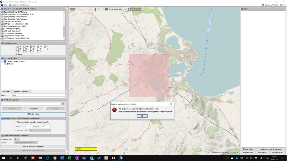 January 12, 2020 at 10:29 #33287Moderator
As it says: enable the grid; currently it is “désactivée”
1 user thanked author for this post.
January 12, 2020 at 16:49 #33289ParticipantHello again,
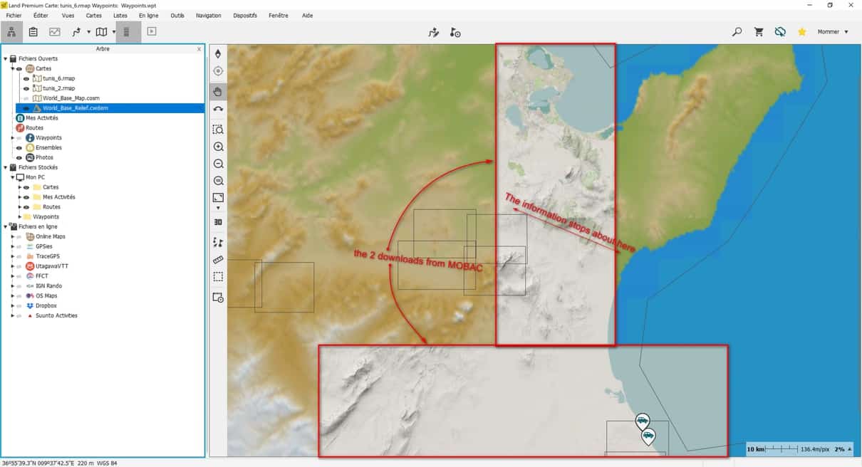
I followed your advices and I could download maps.
I downloaded about 10 layers because MOBAC don’t agree me to download full Tunisia in one time.
I ckecked the result:
the north part is Ok (Tunis, Kelibia,..) but starting the middle of the country nothing appears on the maps!
I tryed the Sousse and Tunis areas in a new atlas to see what’s my mistake: Tunis is ok, Sousse is empty.where’s my mistake?
 January 12, 2020 at 19:43 #33293Moderator
How does the problem area look like in MOBAC interactive window?
Can you try to build ANOTHER map format, like MBTiles ? And check this generated map in Locus.January 12, 2020 at 22:59 #33298ParticipantHi mbe57,
– the map generated with MOBAC is ok
– I’m extracting a map from Sousse area using OpenStreetMap Public Transport, it looks like the problem no more appears.
– importation from the map “Sousse-MOBAC-OSM 4UMaps.eu” in Locus shows the same result: no streets, so cities, only elevation.
At this time my conclusion is that the problem comes from the coverage of OSM in Tunisia.
– I’ll continue to generate the OSM Public Transport expecting I can make it for whole Tunisia. I’ll let you know the resultJanuary 13, 2020 at 06:43 #33300ModeratorWeil, so you go with pre-rendered maps from a Provider, rather than from OSM yourself.
With OAM and Tobias’ themes (and adapting the defaults if you wish) you can control very much what you get into the map. And Tunisia is just 130 MB map file, from which you can generate details up to level 20 if you wish. - AuthorPosts
- You must be logged in to reply to this topic.