


Dear OAM community,
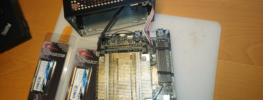
Summer is slowly giving way to a colorful autumn and I have a new test system on my desk.
The old “system”, an ancient Lenovo T410 from the stone age has really become too small, even for testing purposes, and often goes into thermal emergency shutdown.
So I bought a used ASrock Deskmini which was used as a game server.
With a super-efficient Intel i3-8100T and 64gb of (new) RAM as well as some older spare parts plus a few new parts, a quite performant system was created, which is also quite environmentally friendly and quiet.
The 500€ that this system cost (260€ only the RAM) came mostly from reserves of your donations.
What is currently happening is the conversion of all scripts to Windows10 and here to a large extent to WSL, the integrated Linux environment of WIN10 which, believe it or not, is actually quite mature. Now finally the, often buggy and specially adapted, Windows versions of Phyghtmap, osmconvert, osmfilter and especially everything based on GDAL/Python – can run native and always UpToDate in the Linux shell of Win10.
The effort for the conversion is unfortunately considerable, Python2 scripts e.g. do not run any more and must be rewritten, Windows has also naturally again some new bugs.
A word to the users in the forum: I have made myself a bit rare in the forum, unfortunately my resources are limited due to my health. To say it clearly: My arteries are unfortunately quite dense.
Therefore, as soon as the conversion to Win10/WSL is completed, the production system will be updated to a new motherboard + an AMD RYZEN + 128gb RAM and the development system will be transferred to the production machine.
Unfortunately we still need about 1200€ – so if you have some money left over from your christmas bonus it would help us a lot 😉 .
The development computer will be handed over to @Michael who has been developing the OAM world maps for years and as an old IT-professional has the best prerequisites.
Michael will familiarize himself with the (by no means trivial) creation of the OAM maps and, in the long run, will also take over this task.
Health and nice autumn tours
Christian and the small team of OpenAndroMaps
Dear OAM community,
In a nutshell:
I had been struggling with health problems for quite a while this year. I would like to say THANK’s to my comrades-in-arms Tobias and Michael who have kept up the support here.
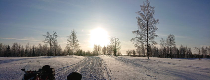
I am now looking forward to a long overdue holiday trip which I will start next week and which will – hopefully – take me to the far north.
Which means that the next map update, any bug fixes and improvements will continue in August (at the moment the computer is runnig full speed and every map rendered until Friday will be uploaded). I hope for your understanding.
BTW:
Looking back on the first half of the year, a lot of improvements have been made to the maps – and Sonny has been busy adding the LIDAR elevation contours.
The Scandinavia_North map will be replaced by a Scandinavia_NorthEast map. From now on the maps Scandinavia_SouthWest + Scandinavia_NorthEast cover Scandinavia completely.
Until autumn, stay healthy and
(again) nice tours with the OAM
Christian
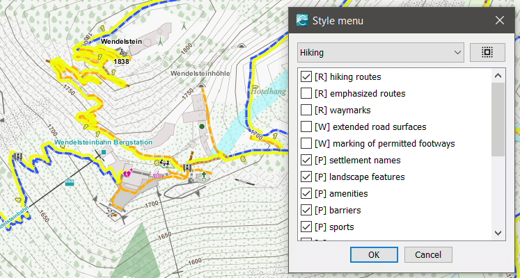 With the new Elevate 4.5, there are lots of changes to the displayed POI symbols and captions. There are now more colors which depend on categories that are identical to the POI options. The categories have been resorted and all symbols have a more unified look. Also the mapstyle options now have category letters (R=Route, W=Ways, P=POIs, A=Areas). That all those changed symbols can be displayed at all I’ve renamed the symbol folder from ele_res to ele-res – the old one can be safely deleted.
You can download it here: https://www.openandromaps.org/kartenlegende/elevation-hike-theme
Dear members of the OpenAndroMaps community,
Another year is drawing to a close, already the 9th year for OAM !
Nine years are a long time in an era in which continous and accelerating change is the only constant.
Without my ally Tobias and Michal and the Members of the OAM Developer-Community OpenAndroMaps wouldn’t be what it is today – probably the best vector maps for all outdoor fanatics and travellers.
I also like to thank all users who made the effort to register in our forum and give hints, suggestions and error reports. This is very important for us as we can be routine-blinded or just lack the time to test every map update for errors. Although our standard is and can only be absolutely professional, we do all this in our rare spare time and with only a tiny budget.
A short summary of the innovations that have been incorporated into the OAM in 2020:
- offline POIs for Locus
- 10m contourlines for most maps
- better representation and resolving of country and state borders
- name-labels adapted to curved ways, an essential inovation
- the overview/general maps by Michael have been completely reworked, he also created the new map coverage pictures in the download area
- webservers moved to a cloud-server at Hetzner.de
Investments were also made in the equipment of the rendering machine:
- The system SSD was changed after 9 years
At the beginning of the year 2 SSD’s were purchased just for file caching,
1* Samsung 970PRO 1TB PCI,
1* Samsung 850PRO 500GB - An own graphics card to free another 2GB of RAM for rendering
Our goal is to sustain and enhance this project and ask you kindly to further support us.
The OAM team wishes you all a merry christmas!
Tobias, Michael, Christian