- AutorBeiträge
- Januar 18, 2023 um 11:15 Uhr #52407
Abi_Suyoso
TeilnehmerI am using LocusMap with Elevate renderthemes to display the map.
I want to how to change the color of toll road from Orange to Blue by modifying .XML file ? Thank youJanuar 18, 2023 um 21:42 Uhr #52418 TobiasAdministrator
Change this rending rule:
<rule cat="toll" e="way" k="toll" v="tl_yes" zoom-min="14"><!–zm–>
				<rule e="way" k="highway" v="*">
					<line stroke="#88DD0000" stroke-width="0.4" stroke-dasharray="1,12" stroke-linecap="round" />
				</rule>
</rule>
Developer of Elevate mapstyle
Januar 19, 2023 um 04:19 Uhr #52422TeilnehmerThanks Tobias.
This is what I did.
<rule cat=“toll“ e=“way“ k=“toll“ v=“tl_yes“>
<rule e=“way“ k=“highway“ v=“*“>
<line stroke=“#0000FF“ stroke-width=“1″
stroke-dasharray=“15,1″ stroke-linecap=“square“ />
</rule>
</rule>Januar 19, 2023 um 05:28 Uhr #52425TeilnehmerUnfortunately, as I just found out,
this does not work for a particular section of the toll road.
Maybe it is because the road is new (less than 1 year in operation)
I guess someone has to put some info on the map itself
so it can be rendered correctly.
Second thing I notice that the Locus Map app takes a longer time
when drawing the map everytime I move the map outside the screen.
I think the reason is because what I did is just putting many blue boxes on top of the existing toll road (already coloured in orange).
Maybe this process taking a lot of computing resource. I don’t know.Thank you.
Januar 19, 2023 um 06:33 Uhr #52428TeilnehmerAnother thing I notice that I need to turn ON
the overlay [P] Car , in order to draw blue lines along the toll road.
Otherwise, I will see the whole toll road still in original Orange colour.My question: Is there a better way to draw the toll road
in Blue colour directly without using any overlay to maket Blue?Thank you.
-AbiJanuar 19, 2023 um 09:48 Uhr #52431 JohnPercyTeilnehmer
Try the following:
<rule e=”way” k=”toll” v=”tl_yes”>
<rule e=”way” k=”highway” v=”*”>
<line stroke=”#0000FF” stroke-width=”1″/>
</rule>
</rule>Removing the cat makes the blue line show always
Removing the dashed line instructions in the „line“ code may also help, but I doubt itVoluntary and Velocity themes - https://voluntary.nichesite.org
Januar 19, 2023 um 12:07 Uhr #52435TeilnehmerThanks John. Yes, it did work.
Coincidently, I also use your Voluntary and Velocity themes.
That’s where I’ve got the idea to use Blue color for toll road, I think.Interestingly, I don’t see a missing blue lines when using Voluntary & Velocity themes. Just curious what happens here.
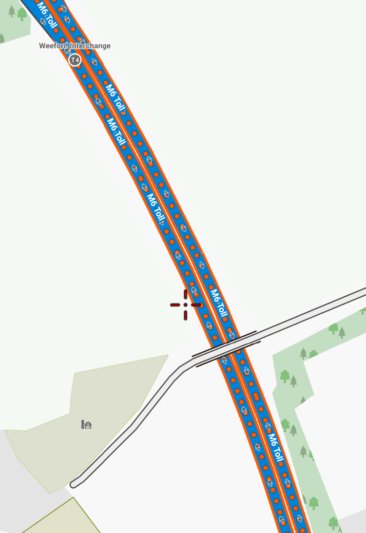
Januar 19, 2023 um 13:16 Uhr #52438JohnPercyTeilnehmerIn Voluntary, a toll road is marked by an orange/red border and orange/red disks on the road at zoom 12 (I thought) and above. Blue marks a motorway.
I’ve checked and the section of road that doesn’t show as toll is not mapped as toll.Voluntary and Velocity themes - https://voluntary.nichesite.org
Januar 19, 2023 um 13:28 Uhr #52441JohnPercyTeilnehmerAttached is a screenshot of a toll road in Voluntary theme. Maybe you have a previous version?
Voluntary and Velocity themes - https://voluntary.nichesite.org
Januar 19, 2023 um 13:58 Uhr #52444TeilnehmerSorry John, have modified your themes a little bit by deleting the little red circles from the road. I just want to see the road in clean blue.
Yes, I use the latest version of the themes.Apart from the missing red circles in my case, Voluntary & Velocity themes shows continuous blue-colored toll roads.
Januar 19, 2023 um 14:17 Uhr #52446TeilnehmerI have confused the meaning of toll road and motorway.
Is toll road the same as motorway but in the case of toll road,
you have to pay some money when driving on it ?Januar 19, 2023 um 16:58 Uhr #52448JohnPercyTeilnehmerMotorway is limited access fast road, usually divided highway (dual carriageway in UK)
Toll road is one where you pay to use, usually fast road but not always.Voluntary and Velocity themes - https://voluntary.nichesite.org
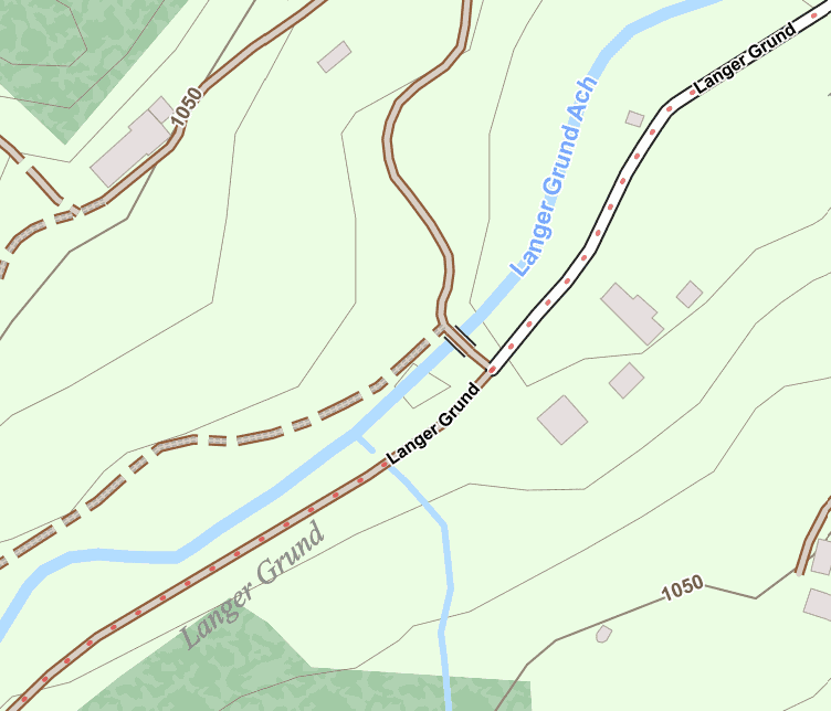
Januar 19, 2023 um 20:55 Uhr #52452TobiasAdministratorPlease keep in mind that Elevate isn’t optimzed for motorized traffic but for hiking and cycling. So marking a toll road has not motorways in mind, but e.g. small private toll roads in the mountains. That’s why red dots make more sense than a wide blue stroke. E.g. in this example one wouldn’t see that the sealed road changes to an usealed track:
Also making it optional is something important as car traffic is sometimes not so really interesting when only using your muscles 😉
Developer of Elevate mapstyle
1 Teilnehmer(n) gefällt dieser Beitrag
Januar 20, 2023 um 14:57 Uhr #52457TeilnehmerThank you so much John, Tobias for your help.
I learn a lot. I use Locus Map mostly for travelling by car. - AutorBeiträge
- Sie müssen angemeldet sein, um zu diesem Thema eine Antwort verfassen zu können.