- AutorBeiträge
- Mai 15, 2022 um 11:53 Uhr #48162
Jethro10
TeilnehmerI’m new to Locus Maps, about 3 weeks, and Openandromaps, coming from OSMand.
I’m an outdoor mountain rural walker and am mainly looking for a few things missing that I usually, and hopefully others, use as landmarks for Navigating.The things missing for me so far are:-
man_made=mineshaft, You have adit’s but not shafts
man_made = spoil_heap
natural=sinkholeA big benefit so far for me is you differentiate between stone walls and fences as the transitions from one to the other really help which I never got on OSMand.
Thanks
Jeff
Mai 30, 2022 um 13:10 Uhr #48262karlchick
TeilnehmerI think it would be useful to add these features to OpenAndroMaps, as they appear to be many 10s of thousands tagged (according to tag-info) and are landmarks that would be useful for navigating in what would be largely sparse/empty landscapes on maps otherwise:
– sinkholes: over 25,000, with a high concentration in Europe
– spoil_heap has over 7,000, mostly in UK and parts of Europe
– mineshaft have over 13,000, with a high concentration in EuropeMai 30, 2022 um 21:55 Uhr #48267 TobiasAdministrator
Hi Jeff,
thanks for those requests.
Our main purpose is providing hiking and cycling maps, and adding additional tags should either be useful or of interest while hiking/cycling. As one focus is also natural landscape natural=sinkhole makes sense. Adits we have mainly as possible attractive POIs while mountain hiking, especially historic one. Therefore historic=mineshaft makes more sense than man_made=mineshaft. man_made=spoil_heap is not so much of an attraction, so I don’t really see the point.
Best regards,
TobiasDeveloper of Elevate mapstyle
Mai 31, 2022 um 11:21 Uhr #48269TeilnehmerOk, thanks for the reply
I understand your POI philosophy as in my 40’s it’s what got me into walking, particularly historic sites like mines, and now over 60, keeps me going.
It may still be worth of consideration for Spoil Heaps as they are the obvious landmarks that give you first sighting and navigation aid to an adit/shaft that may be all but invisible due to collapses and being overgrown.
A problem being is the lack of consistency as most are tagged man_made and abandoned which to most probably mean old! I edit OSM data several times a week usually and I must admit it never occurred to me that it would ever be a problem point, lack of historic tag.One other I often search for on a remote walk, I’m from the UK Lake District, is Lime Kilns, there are a quite a lot of abandoned ones and easy to see, if you consider it worth adding. mostly tagged historic=lime_kiln and mostly appear on small quarries. Only recently I found out they were usually used for producing fertiliser for farms rather than cement.
If it’s ok, as I come across interesting POIs or obvious navigation land marks on walks, not in your XML file I’ll mention them here incase you consider them of worth.
Thanks
Jeff
Juni 1, 2022 um 21:30 Uhr #48279TobiasAdministratorHi Jeff,
for me POIs should be just that – points of interest. Adding POIs that are not of interest just because they might lead to real POI is for me not reason enough to add more to the maps, which a lot of people already think have too much content 🙂
Of course it’s possible to switch unwanted options off, but there are users who never do that and apps that don’t support that.
Yes, mapping consistency and quality of data could be better in OSM.
Speaking of consitency: historic=lime_kiln is one of various variants I found in taginfo, and the Wiki only has man_made=kiln with product=lime and historic=yes as equivalent. I think this is a little bit too special for this kind of map, we only have the more common historic tags.
Best regards,
TobiasDeveloper of Elevate mapstyle
Juni 24, 2022 um 00:08 Uhr #48505Viajero Perdido
TeilnehmerHi.
What do you think about including natural=bay, natural=strait, and similar „non blue fill“ waterbody tags, for the purpose of rendering their names? Would that fit within the mission of OAM?
Thanks.
Juni 26, 2022 um 20:28 Uhr #48530TobiasAdministratorWe have several tags that are mainly for names of landscapes in the tag-mapping, including bay. These have been added six years ago, and tagging conventions have changed, e.g. natural=fjord changed to natural=bay and bay=fjord, and some changed from nodes to ways etc. So a new analysis of those tags is due, incl. natural=strait.
Developer of Elevate mapstyle
1 Teilnehmer(n) gefällt dieser Beitrag
Juli 5, 2022 um 14:09 Uhr #48587 ChristianKAdministrator
I filter out natural=bay prior to rendering.
Reason: These bays cover gigantic areas (mapped as ways) and have a big impact on redering times without adding much information.
1 Teilnehmer(n) gefällt dieser Beitrag
Juli 6, 2022 um 19:40 Uhr #48590TobiasAdministratorI filter out natural=bay prior to rendering.
Reason: These bays cover gigantic areas (mapped as ways) and have a big impact on redering times without adding much information.
Of course you’re right if we would add those as ways. But we only have natural=bay only as nodes in the tag-mapping, so this shouldn’t be an issue?
Developer of Elevate mapstyle
August 7, 2022 um 14:16 Uhr #50728PascalS
TeilnehmerHello, i gave a try to openandromap and elevate theme for a cycling tour on euro6 (Loire valley)… And one missing tag is bike_park… when trying to know if you can securely leave your bike near a touristic site would have been great. OSM does show it efficiently.
Possible to add?
Thanks for this great map and theme
Could be worth it’s own topic sorry if I mess up this threadAugust 7, 2022 um 21:02 Uhr #50733TobiasAdministratorAnd one missing tag is bike_park… when trying to know if you can securely leave your bike near a touristic site would have been great.
You mean amenity=bicycle_parking?
We discussed this several times before, e.g. https://www.openandromaps.org/oam-forums/topic/bike-parking. It’s in the POI database, but won’t be added to the maps.Developer of Elevate mapstyle
1 Teilnehmer(n) gefällt dieser Beitrag
August 8, 2022 um 10:17 Uhr #50745mbe57
ModeratorPS: the POI database approach is more powerful anyway, as it gives distance and direction from your location (depending on App, though).
1 Teilnehmer(n) gefällt dieser Beitrag
August 8, 2022 um 13:41 Uhr #50755TeilnehmerSure POI make more sens. Is ther a way to add that to POI database from OSM tag? .
Anyhow thanks for the answers.Pascal
August 8, 2022 um 13:47 Uhr #50757TobiasAdministratorSure POI make more sens. Is ther a way to add that to POI database from OSM tag? .
Anyhow thanks for the answers.Pascal
It’s already in the POI database which is included in the map zip files.
How you can access these depends on your app, an example is in the attached Oruxmaps screenshot.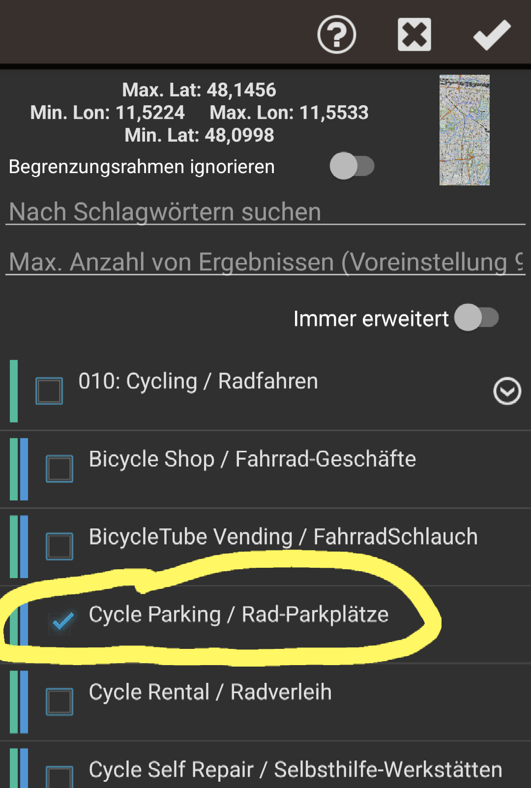
Developer of Elevate mapstyle
August 8, 2022 um 14:10 Uhr #50760Teilnehmerreply to myself.. just found how to activate POI search in Orux.. Sorry still learning 😉
- AutorBeiträge
- Sie müssen angemeldet sein, um zu diesem Thema eine Antwort verfassen zu können.