Verschlagwortet: OS crag
- AutorBeiträge
- Januar 13, 2023 um 12:23 Uhr #52213
geoffmozz
TeilnehmerIt seems I failed to upload the image I promised. Here’s another go…..
In case I fail again which seems likely as I can’t remember how to do it …here’s a good spot to compare Terrain 50 contours with the OS 1:25k contours. https://www.walklakes.co.uk/maps2/?m=56.6492%7C-5.0221%7C15%7Cwaymaps
Januar 13, 2023 um 13:39 Uhr #52218 JohnPercyTeilnehmer
To summarize or findings so far:
1. Not all the OS Explorer crag detail has been transferred to OS Opendata. Maybe it varies by area. I have an outstanding query with OS about this.
2. Excellent as it is, Sonny’s contour data contains some worries or artefacts. OS Opendata contours are almost certainly better.
3. OSM data includes paths not shown on OS maps. That does make OSM maps better for many purposes but please note the warning below.
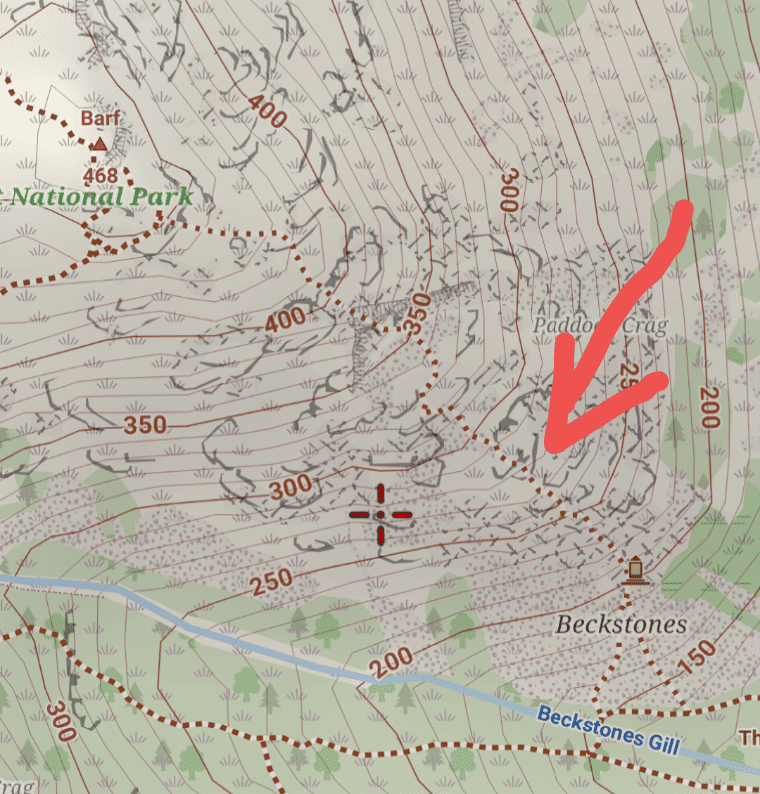
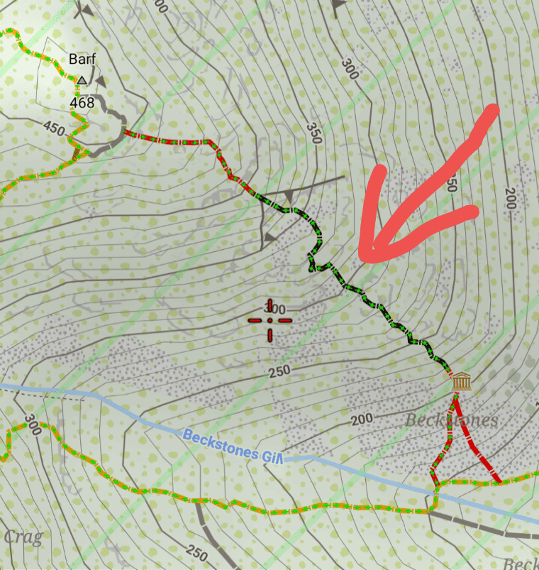
WARNING. In the news recently, it has been reported that Mountain Rescue had be called out to walkers in difficulty climbing Barf. They were following a path mapped in OSM that is difficult and not well marked. Please make sure you use a theme that marks difficult paths and you understand the theme.
In the Voluntary theme, difficult paths can be switched on or off and are indicated by slightly shorter dashes.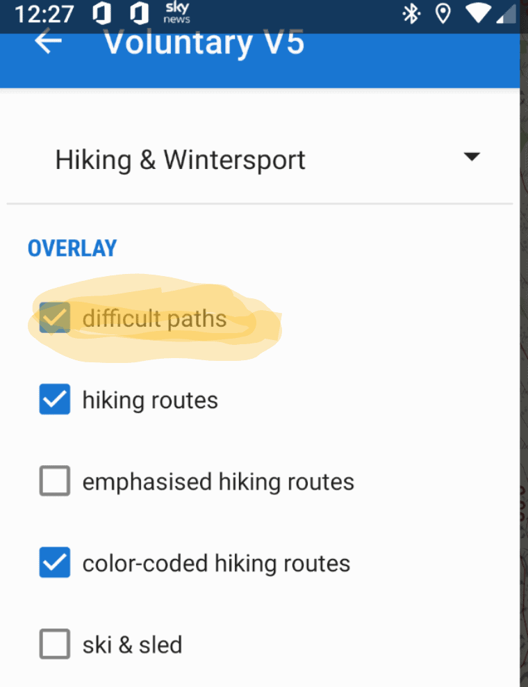
In Elevate the difficulty and visibility is specifically indicated by the store of the line.
Voluntary and Velocity themes - https://voluntary.nichesite.org
Januar 13, 2023 um 13:46 Uhr #52224JohnPercyTeilnehmerThe last sentence above should have read:
In Elevate the difficulty and visibility is specifically indicated by the style of the line.Voluntary and Velocity themes - https://voluntary.nichesite.org
Januar 13, 2023 um 14:45 Uhr #52232TeilnehmerRegarding paths on OS vs OSM maps,
We all need to understand the pros and cons of both map types to use them safely.It’s not just tricky paths on OSM maps that get people in trouble. There are OS paths that cross very dangerous ground too. A few places on Jack’s Rake on Pavey Ark would be fatal if you fell. People have died there. Here’s the map: OS: https://nakarte.me/#m=16/54.46141/-3.10444&l=O/Gbt
OSM: https://nakarte.me/#m=16/54.46141/-3.10444&l=Czt
A surviving widow wanted signs put up at the bottom warning about the difficulties. It’s very hard to stand at the bottom of that cliff and not realise the path angling up across it might be dangerous.eg Good though OS maps are, they still contain well-marked Public Rights of Way that don’t exist as paths on the ground. Some go through dangerous terrain. Keswick MRT were called out to the same spot in a single two week period to people who had got stuck on……a Public Right of Way. They navigated themselves accurately into trouble. Story here: https://keswickmrt.org.uk/wp-content/uploads/2019/01/2019.pdf#page=21
Normally the problem is more to do with the judgement of the people walking, than the mapping.
There will be tricky paths that get uploaded to OSM without the SAC hiking scale. Hikers need to be encouraged to not set aside their common sense. If the ground is making them uncomfortable then they need to find another way. There will always be people who make bad decisions however much good advice they receive…..
Januar 13, 2023 um 14:46 Uhr #52234TeilnehmerPS. The OS Terrain 50 contours get my vote and thanks for chasing the OS about the OpenData crag info.
Januar 13, 2023 um 15:40 Uhr #52240pwb999
TeilnehmerHi,
Fully agree with the comments of geoffmozz.
The problem with a number of apps is that they are using the OSM paths as part of their routing algorithm.
We all use such algorithms in our Car navigation systems and sometimes they might lead us up cul de sacs. Normally no harm though is done. Its very different applying the same principles to walking/hiking routing.Any map whether OS/OSM/Harveys is simply a part of our decision making process.
A „proper“ Guidebook or reputable guide sites such as the excellent http://www.walklakes.co.uk or the Ramblers help us to plan our routes based on our experience, fitness, time of year, weather, flooding etc.Many walkers may have Route A, B as an alternative and C as a backup to A or B.
These routes might also be viewed within Google Earth to give some indication as to whether it actually exists or not. They might compare the OS map with an OSM version (especially Thunderforest Landscape/Outdoor) or an independent Harveys one (if available).No App can do that level of mental processing and planning.
It might be prudent to put on any map a warning „not to be used alone for navigation“ simply to alert casual users that any map is just a guide; features may or may not actually exist and the terrain may be very different to that imagined.
Finally we are blessed in Cumbria to have many excellent Guidebooks to the Fells. Walklakes.co.uk is my principle site for OSM/OS Opendata paper mapping as well as advice as to various routes to consider.
Perhaps we need to remind UK users of the sage and wise words of A.Wainwright “ the best literature of all for the walker is that published by the Ordnance Survey. They are remarkably accurate topographically but there is a crying need for a revision of the paths on the hills: several decades some of them now broad highways, are not shown at all; older paths still shown on the maps have fallen into neglect and can no longer be traced on the ground.“
Hence his justification for producing his own hand sketched maps in his books to include his own observed path network intended as „supplements to the OS maps, certainly not as substitutes.“Hence the popularity of Harveys Maps alas for just the most walked areas in the UK as they have completed their own path network by the own team of surveyors on the ground with a cartographic design intended to meet the needs of today’s walker.
Having the Crag detail is a very useful addition to OAM maps. It provides context to the hill slope and adds to our knowledge when planning a route.
Hopefully the OS will release more data such as walls, barriers, fences and for that to be incorporated into the OSM database which I know is plagued with licensing issues.Congrats to all involved in this major release. Its a step in the right direction subject to the above caveats.
Best wishes to the developers of this product,
Peter B.PS. I would encourage others to download the OS Opendata sets for their own area and compare and contrast. If you convert the Shapefiles to KML these can be viewed in Google Earth and they really do enhance the aerial/satellite imagery.
1 Teilnehmer(n) gefällt dieser Beitrag
Januar 13, 2023 um 21:18 Uhr #52253 TobiasAdministrator
Maybe a different tag-mapping with e.g. natural=cliff_uk tag? Then one could render names without lines, or a more subtle rendering of cliffs so they are still visible but not as strong as in the rest of the world…
@ChristianK, any chance for implementing this?
Developer of Elevate mapstyle
Januar 14, 2023 um 15:09 Uhr #52295TeilnehmerThe holes in the OS opendata will be nothing compared to the holes in the OSM data. Much of the craggy ground in Scotland has no crag markings at all. If it’s possible it would be great to replace the OSM cliff details with OS crags in the UK and theme the UK maps to show those crags properly. Beinn Alligin is a good example.
OS: https://nakarte.me/#m=15/57.58565/-5.57050&l=Czt/Gbt
OSM: https://nakarte.me/#m=15/57.58565/-5.57050&l=CztThe John Thorn Map of Britain available in the Locus Store does exactly that. See attachment of a Glencoe peak. OS vs JTM
Januar 16, 2023 um 20:47 Uhr #52374ninesevenoh
TeilnehmerThe holes in the OS opendata will be nothing compared to the holes in the OSM data. Much of the craggy ground in Scotland has no crag markings at all. If it’s possible it would be great to replace the OSM cliff details with OS crags in the UK and theme the UK maps to show those crags properly. Beinn Alligin is a good example.
OS: https://nakarte.me/#m=15/57.58565/-5.57050&l=Czt/Gbt
OSM: https://nakarte.me/#m=15/57.58565/-5.57050&l=CztThe John Thorn Map of Britain available in the Locus Store does exactly that. See attachment of a Glencoe peak. OS vs JTM
I showed earlier in this thread, with the current gaps in the OS opendata, replacing the OSM cliffs completely with only the OS opendata crags removes quite a few significant, several mile long cliffs in the Peak District, and many smaller notable crags and landmarks. I would guess this occurs in other places also, but the Peak is where I am most familiar. As it currently stands, I feel that for now, both datasets should be displayed somehow, even if they were coloured the same and look a bit messy in places (like the coast examples). If the OS opendata does get updated in the future to show all the crag detail the paper OS 25k maps show (thanks John for contacting OS), I would still argue to include at least the name labels from the natural=cliff OSM tags if not displaying the lines themselves, as the OpenData is just ornaments. There are many named crags in the OSM data, which are useful landmarks and for climbers
1 Teilnehmer(n) gefällt dieser Beitrag
April 12, 2023 um 12:50 Uhr #53869jolly47roger
TeilnehmerI am a bit late to the party….
I am John Thorn whose maps you mention above.
The crags (OS call them ornaments) are drawn vector objects.
Just for information:-
I make my maps from various ‚open‘ vector sources (OS, OSM, Rowmaps.com, Environment agency,…) accumulating a few hundred .MP files. I then go three ways : compile the .MPs to Garmin with MKGMAP; convert them to OSM format to compile as Mapsforge; render the Mapsforge to ’slippy map‘ with Mobile Atlas Creator.
2 Teilnehmer(n) gefällt dieser Beitrag
- AutorBeiträge
- Sie müssen angemeldet sein, um zu diesem Thema eine Antwort verfassen zu können.