- AutorBeiträge
- Februar 28, 2019 um 22:15 Uhr #27381
 TobiasAdministrator
The ski slopes appear from zoom 13.
Would it be possible to modify Elevate so that the ski slopes already appear from the zoom 10.ZL 13 is the hard limit in the maps, that cannot be changed with a theme. See the zoom appear values in tag-mapping.
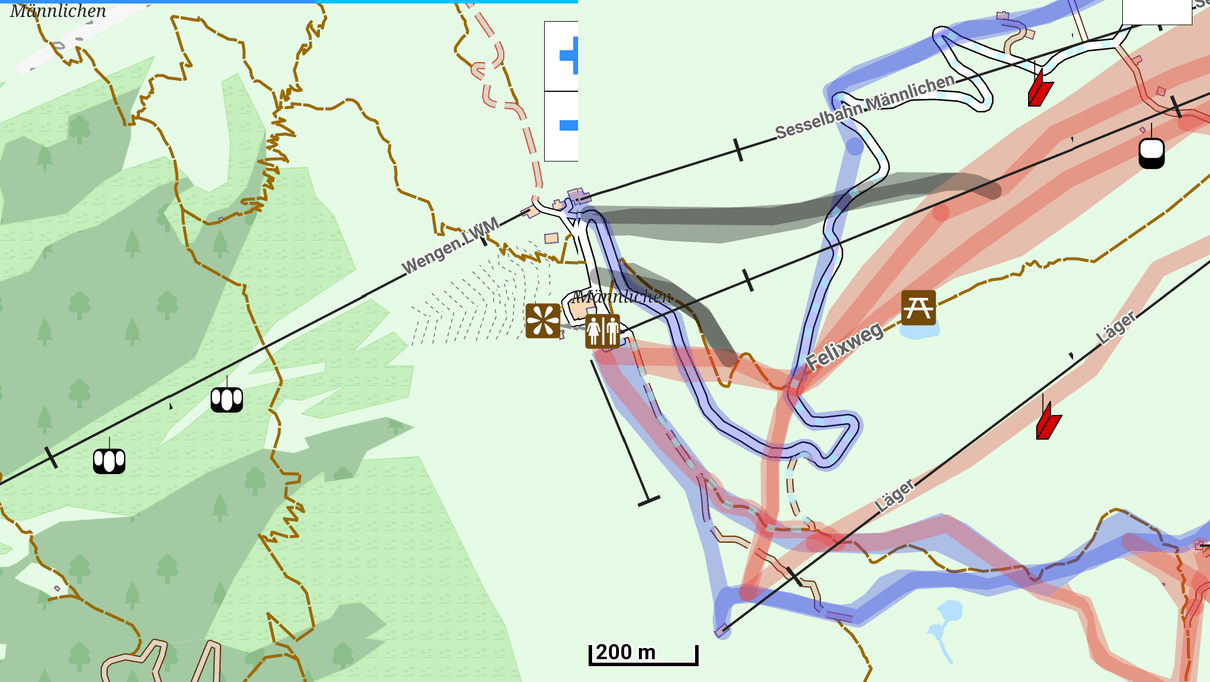
Their are some lifts (e.g. in Arraba Portavescovo see attached screenshot), where the lift name is only shown in zoom level 15, but not in 14.
There has to be enough space to show the names. Maybe using higher priority or display=always would also help.
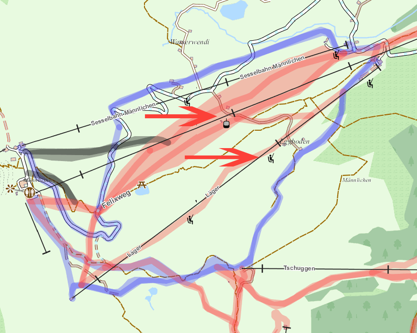
Their seem to be 2 types of piste names. One type is not shown in zoom level 14 (see screenshot, where piste 9 is not shown in all sections of the piste). This is the repeated number along the piste. How can this be shown in zoom level 14.
For Hiking/Cycling route names I used pathtext rules for higher ZL (more repitions), and caption for lower (only one per map tile), as pathtext isn’t very reliable when the route has not long enough straight segments. If you copied that rules, change to pathtext for all ZL, but it is likely that it won’t be shown at all.
Can I include in my project both mapsforge schemas (licensed under GPLv3) and render themes based on Elevate (licences under CC BY-NC-SA 4.0), and package everything under the CC BY-NC-SA license? Aren’t CC BY-NC-SA and GPL incompatible? Sorry if I ask, but I don’t have a clear idea regarding legal issues.
Why do you have to change the license for the mapsforge schemas (and package it)? Both can be included with their separated licenses anyway, as long as your changes are in the same license.
Developer of Elevate mapstyle
1 Teilnehmer(n) gefällt dieser Beitrag
März 1, 2019 um 06:24 Uhr #27385Anonym
InaktivWhy do you have to change the license for the mapsforge schemas (and package it)?
If mapsforge schemas are packaged together with my scripts, it will be easier to use the scripts–it won’t be needed to manually resolve dependencies.
März 1, 2019 um 07:19 Uhr #27394TobiasAdministratorI still don’t get it. Why change the licenses, and what exactly do you want to publish?
Developer of Elevate mapstyle
März 1, 2019 um 08:01 Uhr #27396 EmuxTeilnehmer
Mapsforge has LGPL license.
März 1, 2019 um 11:41 Uhr #27402InaktivSo I can package together files with different licences, right?
I’m confused because on GitHub for instance you usually specify a licence that applies globally to the whole project.
I would package a render theme based on Elevate, as well as some scripts written by me, that would rely on mapsforge xsd styles for instance. I would therefore put also those xsd files in the package.
März 1, 2019 um 17:02 Uhr #27407Jean-Marie
TeilnehmerCurrently I’m working on a rendering of piste areas like this.
Hello Solitone,
Would you be willing to share your prototype version that I like a lot to test.
Thank you
Jean-MarieMärz 1, 2019 um 20:44 Uhr #27410TobiasAdministratorSo I can package together files with different licences, right?
I’m confused because on GitHub for instance you usually specify a licence that applies globally to the whole project.
I would package a render theme based on Elevate, as well as some scripts written by me, that would rely on mapsforge xsd styles for instance. I would therefore put also those xsd files in the package.
So you want to put your work on GitHub? I don’t know how this usually works, but if you stick to the licenses and state them there shouldn’t be a problem.
I packaged symbols of other licenses with Elevate, and did the same.Developer of Elevate mapstyle
1 Teilnehmer(n) gefällt dieser Beitrag
März 1, 2019 um 21:39 Uhr #27412InaktivWould you be willing to share your prototype version that I like a lot to test.
Hi Jean-Marie, sure I will, although for the next few days I will be skiing in Sauze d’Oulx 🙂 and I don’t have the theme file with me. I’ll post it as soon as I get back home.
Cheers
März 1, 2019 um 22:29 Uhr #27414TeilnehmerHi Jean-Marie, sure I will, although for the next few days I will be skiing in Sauze d’Oulx <img class=“wp-smiley“
Hi Solitone,
So you ski practically in the southern Alps and maybe some tracks in my country :-)
I was the week behind in Grindelwald, Wengen in Switzerland and we had 6 sunny days.
I wish you a lot of fun and good weather.
SincerelyMärz 7, 2019 um 12:55 Uhr #27426InaktivHi Jean-Marie, I’m attaching the theme that renders piste areas taking their difficulty into account.
1 Teilnehmer(n) gefällt dieser Beitrag
März 7, 2019 um 19:59 Uhr #27442TeilnehmerHi solitone,
Superb work.
A thousand times thank you.
Do you still have other development ideas for this theme? For example: type of lifts I saw with the OpenStreetMap Default theme
Jean-Marie
 März 8, 2019 um 06:34 Uhr #27448Inaktiv
I thought that type of lift was already shown. Is the map in your screenshot rendered through the standard mapsforge theme? Could you post another screenshot of the same map rendered with the theme I attached?
März 8, 2019 um 11:08 Uhr #27450TeilnehmerHi solitone,
It is with pleasure that I send you this information.
Jean-Marie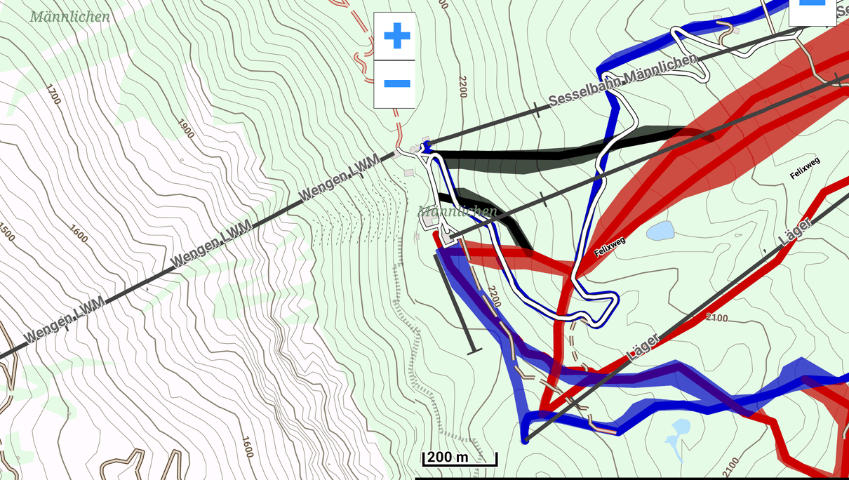
 März 8, 2019 um 20:50 Uhr #27463Inaktiv
Are you sure you’ve copied the Elevate-winter theme in the same directory containing the vanilla Elevate theme? Because in my case aerialways icons are shown. In the following example, a chair lift and a drag lift:
1 Teilnehmer(n) gefällt dieser Beitrag
März 8, 2019 um 21:57 Uhr #27466TeilnehmerOnce again thank you.
I work with Cruiser under Windows and I forgot the file ele_res and under Android I had cleaned the folder themes and only the Elevate-winter was installed :-(
Now it works 🙂1 Teilnehmer(n) gefällt dieser Beitrag
- AutorBeiträge
- Sie müssen angemeldet sein, um zu diesem Thema eine Antwort verfassen zu können.