- AutorBeiträge
- September 20, 2017 um 16:23 Uhr #20173
 JohnPercyTeilnehmer
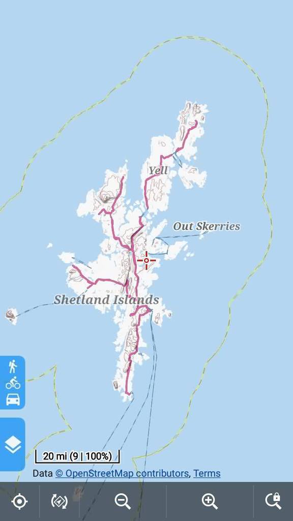
At present the names for larger islands do not show on the maps. As far as I can see this is because larger islands are multipolygon relations. Would it make sense to treat them in the same way as (for example) desert, forest, wood, orchard, glacier, mountain_range, mountain_area etc.?
See https://wiki.openstreetmap.org/wiki/Tag:place%3Disland#Large_islands and https://www.openstreetmap.org/#map=15/56.3973/-5.5410Voluntary and Velocity themes - https://voluntary.nichesite.org
September 20, 2017 um 17:08 Uhr #20175 ChristianKAdministrator
Hi John,
The reason why place labels tagged as within areas/ways/multypolys are not shown on the map is that „places“ are only included as NODES in the tagmapping. So only dedicated nodes „place=island“ is shown on the map.
For me its perfect easy to handle the islands in the same way as other poly-labels = place labels in the middle of the island and add a bboxweight tag so that the labels of the bigger islands are shown at low zoom rates , labels from smaller islands at (eg) level 15.
However, there will be duplicate labels with islands where a single node + a place as tag within MP.
See on the shetlands: Noss, Mousa, St.Ninians, …
It would be possible to remove the single nodes in tagtransform prior to making poly_labels so only place=island drived from MPs are shown on map.Themes would have to be modified to render island labels according to size of the polygon (bboxweight)
@John,@Tobias – what your opinion on this.
Best regards
Christian1 Teilnehmer(n) gefällt dieser Beitrag
September 20, 2017 um 17:13 Uhr #20177 JohnPercyTeilnehmer
That seems a good idea to me.
PS The forum seems to have a mind of its own at present. I posted „seems“ above and it showed as „means“. I’ve corrected that but it now changes my British quotes to German ones.Voluntary and Velocity themes - https://voluntary.nichesite.org
September 20, 2017 um 19:03 Uhr #20179 TobiasAdministrator
Fine for me. I’m not sure if bboxweight is really needed, this needs testing.
Removing nodes for place=island is maybe not a good idea, as there are possibly islands that don’t have place=island on the ways.
While you’re at it, place=islet and place=archipelago should have the same treatment then. Other places hopefully still have the node as main tag, although it seems that ways/MP are getting more common.Developer of Elevate mapstyle
1 Teilnehmer(n) gefällt dieser Beitrag
September 20, 2017 um 19:43 Uhr #20183 ChristianKAdministrator
The forum seems to have a mind of its own at present
Its WordPress…
https://en.wikipedia.org/wiki/The_Sorcerer%27s_Apprentice
😉
September 21, 2017 um 07:37 Uhr #20188 ChristianKAdministrator
place=islet and place=archipelago
For shure, eg. shetland islands are combined in one MP tagged as place=archipelago.
I will prepare UK_Scotland and GB Map for testing.September 21, 2017 um 08:49 Uhr #20190 ChristianKAdministrator
Here are the csv’s of all poly_labels with sizes.
You will notice that (small) St.Kilda is tagged as archipelago and not as an island.EQ keys for sizes (same as bevore):
bBoxWeight tiny 1,2,3,4,5,6,7,8,9
bBoxWeight xsmall 10,11,12,13
bBoxWeight small 14,15,16,17,18,19,20
bBoxWeight mid 21,22,23,24
bBoxWeight large 25,26,27,28
bBoxWeight xlarge 29,30,31,32
bBoxWeight xxlarge 33,34,35,36,37,38,39,40
bBoxWeight xxxlarge 41,42,43,44,45,46,47,48,49,50,51,52,53,55@John: The IDs in the csv are internal IDs of the poly_labels and don’t match any ID of OSM
zoom_appear: archipelago=6, islet=12, island=10
Maps will follow.soon
1 Teilnehmer(n) gefällt dieser Beitrag
September 21, 2017 um 18:53 Uhr #20203 ChristianKAdministratorThis reply has been marked as private.
1 Teilnehmer(n) gefällt dieser Beitrag
September 21, 2017 um 20:23 Uhr #20213 JohnPercyTeilnehmerThis reply has been marked as private.September 21, 2017 um 22:25 Uhr #20215
 TobiasAdministrator
Thanks Christian, works well as always.
Developer of Elevate mapstyle
September 22, 2017 um 11:06 Uhr #20225 ChristianKAdministrator
I’m looking forwrd to see new place=archipelago in themes = to see „Shetland Islands“ in maps
🙂 🙂September 22, 2017 um 17:55 Uhr #20236 JohnPercyTeilnehmer
Voluntary and Velocity themes - https://voluntary.nichesite.org
1 Teilnehmer(n) gefällt dieser Beitrag
September 23, 2017 um 14:02 Uhr #20263 JohnPercyTeilnehmerThis reply has been marked as private.
1 Teilnehmer(n) gefällt dieser Beitrag
September 25, 2017 um 23:42 Uhr #20318 JohnPercyTeilnehmer
Will this be incorporated in the next release of maps?
Voluntary and Velocity themes - https://voluntary.nichesite.org
September 26, 2017 um 11:16 Uhr #20321 ChristianKAdministrator
Hi John,
Will this be incorporated in the next release of maps?
Yes, of course!
Its a real improvement for the maps – thanks for this great idea!Best regards
Christian1 Teilnehmer(n) gefällt dieser Beitrag
- AutorBeiträge
- Sie müssen angemeldet sein, um zu diesem Thema eine Antwort verfassen zu können.
