- AutorBeiträge
- Januar 13, 2023 um 13:13 Uhr #52215
geoffmozz
TeilnehmerJohn, I’ve just updated my OpenAndroMap of Britain and delighted to see that OS crag markings are now part of the map. That is great for those of us who wander the hills. The standard OSM crag markings are a weakness of OSM mapping for those of us who enjoy wilder mountain walks.
I may have done something wrong but the Elevate theme doesn’t work well with the crags on my phone. I can still see the old OSM crag markings clearly marked in a bold dark colour. The new OS crags appear in a really faint grey and are barely visible. The screenshot I saw of your map with the elevate theme looked good……
However I then tried your Voluntary theme. That works much better. The old crag markings have gone and the new OS crags are showing clearly. Thank you.
I haven’t spent a lot of time with the map in it’s new form but one thing hit me instantly. The ducks. Can I persuade you to lose the green ducks that denote a ’nature reserve‘ or similar? The faint yellow wash is more than enough IMO. The south side of Glencoe and much of Ennerdale are covered in green ducks. I’m not a fan of the distracting ducks. I don’t like the green diagonals that cover National Parks with the Elevate theme either but I can switch those off using ‚[A] Borders + special areas‘ in the theme options. If I could kill the ducks and lose the yellow wash I would 🙂
Any chance of giving the yellow-wash-duck-haters a switchable option in the theme? A ‚Borders + special areas‘ for the Voluntary theme?
Most of the time I couldn’t care less if I’m in a national park, a nature reserve or nothing-special-wild-country. I just want good accurate mapping that helps me navigate my route well.
I’m starting a campaign right here to „Ditch the ducks“. 🙂 I’ve got my fingers crossed…..
Januar 13, 2023 um 14:25 Uhr #52229 JohnPercyTeilnehmer
In the latest UK maps, old style crags have been reintroduced to the maps alongside OS „ornamental“ crags as the OS Opendata is incomplete. I have attempted to make the old style markings blend in.
I’m glad you like it.
I have some sympathy with you over the ducks. I had been thinking about them myself. I think they are too intrusive on large areas. I thought about only using them on specific nature reserves (which I find very useful) and not on natural „protected areas“. That would exclude Wild Ennerdale but not Glencoe, which is a National Nature Reserve. I don’t really want to add an extra option as I have tried very hard to limit the choices to a manageable number. Perhaps I could make the ducks more see through.Voluntary and Velocity themes - https://voluntary.nichesite.org
Januar 13, 2023 um 14:54 Uhr #52236TeilnehmerNo John….your intuition about the ducks is correct. Get rid!!! An opacity change won’t do it. You know it makes sense….the OS produce good maps. How many ducks do they use? I rest my case….
Januar 13, 2023 um 15:13 Uhr #52238TeilnehmerYou have done a good job of blending the OSM crags with the OS crag detail. However if you can persuade the OS to fill the holes in their opendata crags then I think the UK maps will be best served by just using the OS crags and losing the OSM markings altogether. The OS crag detail is very good indeed.
Januar 13, 2023 um 18:10 Uhr #52244JohnPercyTeilnehmer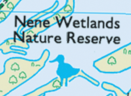
(From Ordnance Survey)
I’m afraid I couldn’t find an Avocet symbol for Voluntary, so I was stuck with a duck.Voluntary and Velocity themes - https://voluntary.nichesite.org
Januar 13, 2023 um 20:33 Uhr #52247TeilnehmerJohn, it’s no use deflecting.
I can forgive the species change. With the way things are in the UK at the moment it’s probably very hard to find good avocet icons. Brexit? Who knows. That isn’t my complaint,
There are too many ducks, by a factor of about 100.
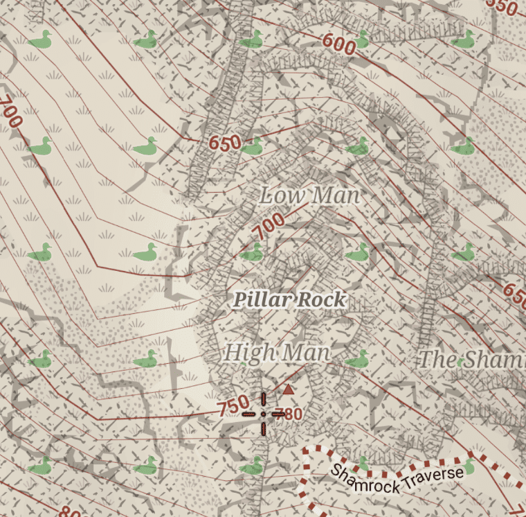
I note that you side-stepped my important question which was „the OS produce good maps. How many ducks do they use?“ I visited the Kinder Scout National Nature Reserve to get a good answer to my question. Here’s the map: https://nakarte.me/#m=15/53.38472/-1.87853&l=O/Gbt
I took the time to count how many avocets the OS use. The answer, in case you were wondering is……One. A single iconic avocet marks the Nature Reserve. I applaud the OS for their good judgement.I’ve just opened a section of the OpenAndroMap using your Voluntary theme and it looked like a full-on murmuration. I counted 104 ducks on the screen. That’s 103 too many. I must give you a quizzical look which asks..“what were you thinking“? Screenshot comparison attached.
However fond you are of waterfowl, I implore you to not let that cloud your judgement and…’Ditch the ducks‘.
A single duck would be tolerable. Any opacity you like.
Januar 13, 2023 um 22:11 Uhr #52264 @afgb1977Teilnehmer
In my opinion, the representation of nature_reserve should still be kept as an area and not as a POI symbol. I want Voluntary to tell me that I am seeing a natural_reserve area on the map, I want it to show the boundaries of natural_reserve especially when it overlaps or borders on terrain with other types of areas. As a symbol (a duck), it would represent a single point within a potentially gigantic area and would lose the reference to the natural_reserve area. Using „symbol“ combined with „<area fill=“#xxx“ for natural_reserve could be visually confusing considering it may be within other natural areas and may or may not match the shape and size of those other areas. Simply put, I want to see ducks between trees when two areas overlap or border.
P.S. Voluntary has 3 nature preserve svgs spread across 2 folders (svg – patterns), each of these svgs has a single duck.@afgb1977
Januar 13, 2023 um 23:11 Uhr #52272TeilnehmerI just want to ‚ditch the ducks‘. The nature reserves are already marked with a colour wash, the reserves name is repeated across the area and there’s a marked border. That’s enough. See attached pic.
Repeating symbols are OK if they represent something on the ground, trees, marsh, rocks, scree etc. The duck-matrix is a distraction, just as the green diagonals across national parks are with Elevate….IMO!
Januar 13, 2023 um 23:21 Uhr #52276JohnPercyTeilnehmerMy present plan is to only mark area that have been mapped as leisure=nature_reserve, and to reduce the intensity of the ducks. Using a single poi just won’t work for reasons mentioned above. I have tried it in any case. I do believe that making the ducks less intrusive will make a lot of difference.
But @geoffmozz, please feel free to see if you can get any more support for your request.Voluntary and Velocity themes - https://voluntary.nichesite.org
Januar 14, 2023 um 14:12 Uhr #52280TeilnehmerSet the duck transparency to 100%…. perfect!
At roughly 60km x 30km the Peak District National Park is bigger than the biggest nature reserve in the country (the Wash). The colour wash with your Voluntary theme makes the area obvious, the boundaries are marked and the repeating name makes it clear what the area is. No repeating symbol required.
A single POI is exactly what the OS use for nature reserves and they don’t augment that with anything else. If the reserve is spread over a wider area then they might use a couple more symbols. eg Leighton Moss & Alvecotes
https://nakarte.me/#m=15/54.16727/-2.79501&l=O/Gbt
https://nakarte.me/#m=16/54.15024/-2.80388&l=O/Gbt
https://nakarte.me/#m=16/52.63859/-1.63176&l=O/GbtYour theme adds a colour wash, a repeating name and a marked boundary. Combine all of that with a POI and that’s more than enough to identify a reserve and see the area it covers. Anyone who really needs to know exactly where the reserve boundary is, can browse the border.
I’m curious…can you think of any good maps that use a repeating symbol across a wide geographic area that doesn’t denote anything on the ground?
Januar 14, 2023 um 14:34 Uhr #52286eyEa
Teilnehmermy 2 cents re ducks:
I don’t really mind the density of them ducks, slightly reduced opacity looks good to me. But I have to admit when I first encountered them I had no idea what they meant – had to look up their meaning in the legend.> can you think of any good maps that use a repeating symbol across a wide geographic area that doesn’t denote anything on the ground?
Airports are one thing that comes to my mind which is marked with repeating plane-icons in many map themes.
@geoffmozz: imho: you made your suggestion to the theme author, he heard you but doesn’t agree with you, you should stop at that. If the ducks annoy you that much you can easily mod the theme to your liking, e.g. delete „nature_reserve_small.svg“ and „nature_reserve_large.svg“Januar 14, 2023 um 14:35 Uhr #52288TeilnehmerThe Voluntary themes are now available on a fixed URL:
fyi, those permalinks are dead
Januar 14, 2023 um 15:30 Uhr #52298Teilnehmer@eyEa We will just have to disagree about the ducks 🙂 I’m pushing John because I value what he’s doing and care about the result. I spend much of my leisure time in some mountainous areas that now appear to be duck sanctuaries. Every change in zoom level on the phone changes the position of the ducks. Not a fan. It doesn’t help with the map reading on a windswept mountain top. So….you like the ducks…each to their own!
Thanks for your tips on how to modify the theme. If John sticks to his guns then I will do that.
Interested to hear that airports often have repeating symbols over ‚em. Not on my OpenAndroMap. Can you share an example?
Januar 14, 2023 um 15:32 Uhr #52300TeilnehmerElevate airport screenshot
Januar 14, 2023 um 15:48 Uhr #52303TeilnehmerThose planes are about as redundant as the ducks. What map is that?
I’ve just removed the duck SVGs. Worked a treat. Thank you!
- AutorBeiträge
- Sie müssen angemeldet sein, um zu diesem Thema eine Antwort verfassen zu können.