Tagged: OS crag
- AuthorPosts
- October 20, 2022 at 17:22 #51508
 ChristianKKeymaster
Next update of maps will include k=“os_open_data v=“crags“
Hi John,
I finished the scripts for external layers and
k=“os_open_data v=“crags“
will be included in Wales,Lake_District,Scotland,Shetlands and GB mapsUnfortunately the free OS Dataset is not Available for Ireland and Isle of Man
1 user thanked author for this post.
October 20, 2022 at 21:36 #51510 TobiasKeymaster
I don’t think that this is an issue – I’v taken a look at several occasions where crags and cliffs are in the same place and for me this is OK
I only checked a bit in the Shetlands map, and I made crags a bit brighter than cliffs, some not so nice examples:
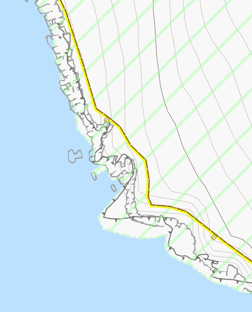
It might be that the situation is okayish most of time now, but with more cliffs being mapped this can change.
I thought about an extra tag-mapping definition for those maps, as you have for e.g. Netherlands etc., just the same as before but just cliff missing.
But I’m also not sure about how big the issue is, as overpass is here no big use as it doesn’t show crag areas – only scanning the maps at ZL13 shows where issues might be…Hope everything is well with the PAXes 🙂
Developer of Elevate mapstyle
1 user thanked author for this post.
October 21, 2022 at 08:25 #51515ChristianKKeymasterThe effort for makeing the crags was considerable but the result is IMO worth every hour and the increase of Mapsize !!!
And as a sideeffekt the make_scripts are now capable for including multiple external layers – once these are preprozessed with unique ID’s.
OK,
- UK-Wales
UK-LakeDistrict
UK-Shetlands
UK-Scotland..Maps are ready for download from the regular “europe” page
GB tomorrow
October 21, 2022 at 09:03 #51518TobiasKeymasterThanks Christian!
New Elevate update will come ASAP, but at the moment we’ve got the party weekend of a newly 8 year old coming up. More work than 200kg PAX 😉Developer of Elevate mapstyle
1 user thanked author for this post.
October 21, 2022 at 09:41 #51520 JohnPercyParticipant
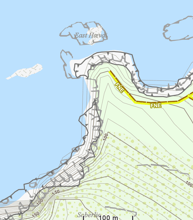
I noticed that the mapping of the cliff area in Foula you are looking at doesn’t follow OSM wiki. It is mapped as an area, rather than a way at the top of the cliff. Properly mapped cliffs don’t look so ugly with both OS ornaments and OSM cliff lines shown at the same time.
However, I realise we need to work with the data, not with an ideal!Voluntary and Velocity themes - https://voluntary.nichesite.org
2 users thanked author for this post.
October 21, 2022 at 12:30 #51522ChristianKKeymasterI thought about an extra tag-mapping definition for those maps, as you have for e.g. Netherlands etc., just the same as before but just cliff missing.
And this is where the problem beginns:
GB ist mapped as tagmapping: URBAN
Scotland,Wales,Shetlands,LakeDistrct as more detailed tagmapping: WIDEAnd those cliffs mapped as polys IMO are simply wrong by definition (as John mentioned), now clear to see by the crag overlay
Well, nothings perfect….
BTW: I cleared those cliffs at Foula…..
1 user thanked author for this post.
October 21, 2022 at 12:32 #51524ChristianKKeymasterQuestion:
Do the OS Contourlines better match reality than the Sonny/Viewfinder ones ?
🙂October 21, 2022 at 13:50 #51526JohnPercyParticipantThe Viewfinder contour lines used to have some glitches in them but I think Sonny has dealt with those in the latest improved versions. OS contours generally are at 10m vertical interval, though in flatter areas it may be 5m.
OS contours are missing in quarries, where the topography may be changing.Voluntary and Velocity themes - https://voluntary.nichesite.org
October 21, 2022 at 13:54 #51528TobiasKeymasterI thought about an extra tag-mapping definition for those maps, as you have for e.g. Netherlands etc., just the same as before but just cliff missing.
And this is where the problem beginns:
GB ist mapped as tagmapping: URBAN
Scotland,Wales,Shetlands,LakeDistrct as more detailed tagmapping: WIDEAnd those cliffs mapped as polys IMO are simply wrong by definition (as John mentioned), now clear to see by the crag overlay
Well, nothings perfect….
BTW: I cleared those cliffs at Foula…..
But the other example in my post has correct mapping, and it doesn’t really look good with cliffs meandering over crags. IMO cliff is superflous here.
Developer of Elevate mapstyle
October 21, 2022 at 18:31 #51536JohnPercyParticipantSome of the places I know in Wales look really good with this new mapping. I tend to agree that the OSM cliffs are no longer needed, though it would be OK to leave them if necessary.
Voluntary and Velocity themes - https://voluntary.nichesite.org
October 24, 2022 at 08:26 #51584ChristianKKeymasterFYI:
I’m pretty sure I’ve found a solution to skip a list of tags, which are defined during map definition in a column of the central spreadsheet in which all variables of the maps are defined, for individual maps – without disturbing the workflow.
The definition of the tags that should not be included is simply done (as with the ext_layers) as a csv list delimited by “#” – as said for each map separately.
I will implement this sometime this week
So you can assume that the cliffs will no longer be included in the maps where the crags appear.
… maybe not for November update …October 24, 2022 at 14:37 #51586JohnPercyParticipantI wonder if the same should be done with the tags for ridge, arete and gorge. It looks to me that the mountainous tags like cliff and ridge will be duplicated by the crag ornaments. The example of gorge I found that was marked as a single way was not marked by OS ornaments, which is probably understandable.
Voluntary and Velocity themes - https://voluntary.nichesite.org
October 24, 2022 at 19:08 #51588ChristianKKeymasterridge, arete and gorge
Could be done
Where:
1.) When a tag/value is removed > all equivalents are removed too
2.) Values as EQ under a “main” tag/value can’t be removedIn this case no Problem….
@Tobias: Do you agree in removing : ridge, arete and gorgeFrom my side we can release Crag_Layer + skip_tags with 1st of November if your resourced allow an update of Elevate.
October 24, 2022 at 20:29 #51590JohnPercyParticipant“Gorge” is in fact mapped very infrequently in Great Britain and often as not, incorrectly.
Re-reading the wiki, I think it should be best rendered as a name placeholder. The cliffs on either side should be mapped as cliffs, and the gorge is mapped along the bottom.
In any case, I suggest gorge is left in.Voluntary and Velocity themes - https://voluntary.nichesite.org
October 24, 2022 at 22:02 #51592TobiasKeymasterFor me ridge, arete and gorge are a different case than cliff, especially as the names of these are for me more important than the ways. Also ridges aren’t that rocky, so maybe crags are missing anyway.
Of course for cliffs there can also be names, but the unnamed ones are much more common and overlapping with crags. As I wrote above best would be a special theme/option for maps with crags, but for most of the maps it would be unnecessary.Developer of Elevate mapstyle
- AuthorPosts
- You must be logged in to reply to this topic.