- AuthorPosts
- May 2, 2023 at 00:45 #54042
 JohnPercyParticipant
The new LoMaps now available in the Locus Store are much more mainstream Mapsforge but require updated themes. A preliminary version of Voluntary is now available for download from the link below. Please delete your old version in Locus first.
Voluntary and Velocity themes - https://voluntary.nichesite.org
May 18, 2023 at 23:43 #54180JohnPercyParticipantThe latest version of the Voluntary themes now supports OAM maps and both new and old LoMaps.
It also supports OSMC hiking trail markers (in Hiking style). See link below.Voluntary and Velocity themes - https://voluntary.nichesite.org
May 19, 2023 at 14:00 #54181JohnPercyParticipantSome updated screenshots
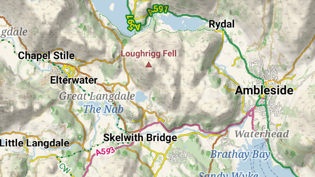
Voluntary and Velocity themes - https://voluntary.nichesite.org
1 user thanked author for this post.
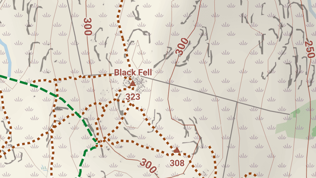
June 29, 2023 at 18:26 #54234JohnPercyParticipantVoluntary V5+ works with Oruxmaps beta, Cruiser and Locus (OAM maps) and displays contour heights orientated to be read looking uphill, as is conventional with maps. I find this change incredible helpful.
It may work with other apps as they update.Voluntary and Velocity themes - https://voluntary.nichesite.org
4 users thanked author for this post.
July 15, 2023 at 11:43 #54417JohnPercyParticipantThe latest Voluntary V5 now works with the full version of Oruxmaps.
Voluntary and Velocity themes - https://voluntary.nichesite.org
1 user thanked author for this post.
August 10, 2023 at 16:21 #54722Phil
ParticipantJohn, the Voluntary V5 theme is really world class, so I would like to take this opportunity to thank you for your great work.
As a small feedback, I would like to say that I sometimes wished for a stronger representation of country borders when using the theme. While they don’t matter much within the EU or UK, an accidental border crossing in other regions can quickly lead to big problems like arrest, long interviews or deportations. Often the borders in remote regions are not marked at all or not continuously.
Attached is an example of a clearly visible country-border representation in Elevate and a rather inconspicuous representation in Voluntary that can hardly be distinguished from region-borders.
1 user thanked author for this post.
August 11, 2023 at 09:28 #54726JohnPercyParticipant@Phil
You might like to try a modified version of Voluntary I’ve just done. It’s difficult to strike the balance between EU transparent borders and life-threatening borders elsewhere, especially having used most colours already! Red is for international borders, green is for boundaries within the country which may or may not be important.
Although this beta is packaged for Locus it also works with Orux, Cruiser, c:geo nightly build.
Beta version – https://voluntary.nichesite.org/beta.htmlVoluntary and Velocity themes - https://voluntary.nichesite.org
1 user thanked author for this post.
August 11, 2023 at 14:56 #54728JohnPercyParticipant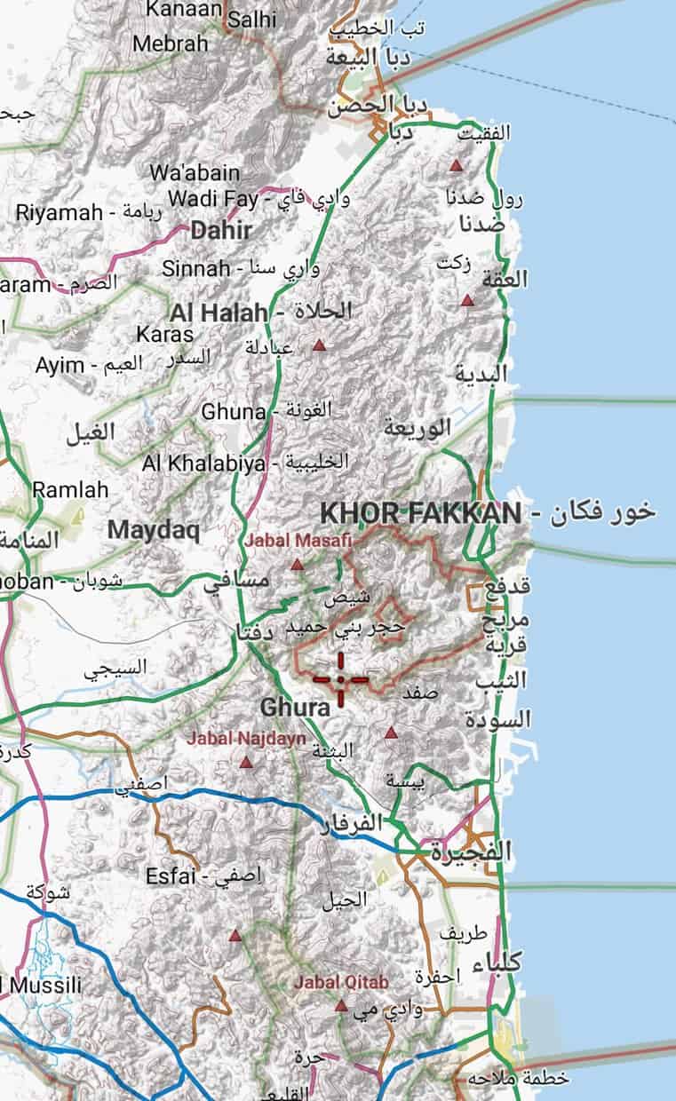
Voluntary and Velocity themes - https://voluntary.nichesite.org
August 11, 2023 at 17:18 #54730ParticipantWow, i didn’t expect to get a response so quickly and such a great one at that!
I really like the representation of the borders in the beta version! I will definitely use this version. Thank you very much John!
I don’t want to overuse your helpfulness, but I have another small question about the representation of borders: Sometimes when I see a border on the map, I wonder what it belongs to (for example, region borders within a country I’m not that familiar with, or islands between several countries that all have their own circular borderline). In some themes you could zoom-in very near to the border and see the names of the countries/regions on both sides of the border-line. With Voluntary and Elevate, this does not seem to work for me at the moment. Is this labelling really theme-dependent or is it rather due to the map or software? If it is theme-dependent, would it be very complicated to activate the labelling for Voluntary at the most detailed zoom level?
1 user thanked author for this post.
August 11, 2023 at 18:42 #54731JohnPercyParticipant@Phil
I saw an identical request recently and the answer appeared to be that it is not really possible with these maps.
I’ve just done a trial. There is no way to tell which country is on which side of the line.
In fact the border line is often mapped twice or three times, once for each country and once as the border line between the two! In the screenshot only the Polish border label is showing.
There is a further problem for borders that completely encircle a country that results in the text also appearing in horizontal and vertical alignment within the country.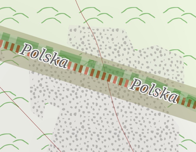
Voluntary and Velocity themes - https://voluntary.nichesite.org
1 user thanked author for this post.
August 12, 2023 at 18:14 #54733ParticipantOK, thank you for the trial and your very detailed answer!
August 16, 2023 at 00:51 #54736JohnPercyParticipantThe latest version of the Voluntary theme has been uploaded, with support for cycle super highways, optional emphasised cycleways, improved marking of frontiers and other boundaries.
Thanks for support and helpful suggestions.
Voluntary and Velocity themes - https://voluntary.nichesite.org
December 15, 2023 at 22:17 #55135eyEa
ParticipantThere’s a bug with marpsforge VTM and Velocity (not Voluntary), the theme can’t be loaded due to some element rendering with height=0.
Unfortunately I couldn’t figure out which element is causing this.Here’s the relevant part of stacktrace:
[main] render theme invalid
org.oscim.theme.IRenderTheme$ThemeException: width and height must be > 0
at org.oscim.theme.XmlThemeBuilder.read(XmlThemeBuilder.java:121)
at org.oscim.theme.ThemeLoader.load(ThemeLoader.java:49)
at org.oscim.theme.ThemeLoader.load(ThemeLoader.java:45)
at org.oscim.map.Map.setTheme(Map.java:197)
at org.oscim.map.Map.setTheme(Map.java:189)
at cgeo.geocaching.unifiedmap.mapsforgevtm.MapsforgeThemeHelper.reapplyMapTheme(MapsforgeThemeHelper.java:157)Attached screenshot is from XmlThemeBuilder.java, method createLine(), just before this exception is thrown.
December 15, 2023 at 22:25 #55138ParticipantThere’s a bug with marpsforge VTM and Velocity (not Voluntary), the theme can’t be loaded due to some element rendering with height=0.
Unfortunately I couldn’t figure out which element is causing this.Here’s the relevant part of stacktrace:
[main] render theme invalid
org.oscim.theme.IRenderTheme$ThemeException: width and height must be > 0
at org.oscim.theme.XmlThemeBuilder.read(XmlThemeBuilder.java:121)
at org.oscim.theme.ThemeLoader.load(ThemeLoader.java:49)
at org.oscim.theme.ThemeLoader.load(ThemeLoader.java:45)
at org.oscim.map.Map.setTheme(Map.java:197)
at org.oscim.map.Map.setTheme(Map.java:189)
at cgeo.geocaching.unifiedmap.mapsforgevtm.MapsforgeThemeHelper.reapplyMapTheme(MapsforgeThemeHelper.java:157)Attached screenshot is from XmlThemeBuilder.java, method createLine(), just before this exception is thrown.
I was able to identify the offender after all:
<rule e=”way” k=”highway” v=”steps” zoom-min=”13″>
<line stroke=”#8F6A00″ stroke-width=”0.5″ scale=”all” stroke-dasharray=”0.2,0.2″ stroke-linecap=”butt”/>
</rule>After changing 0.2 to 0.5 (to validate that this is the line) it works
1 user thanked author for this post.
December 15, 2023 at 23:31 #55139JohnPercyParticipantThanks for the report. It does however mystify me somewhat.
Voluntary has a very similar code segment, which you say works.<rule cat=”paths” e=”way” k=”highway” v=”steps” zoom-min=”12″>
<line stroke=”#9A4A09″ stroke-width=”0.7″ stroke-linecap=”butt”/>
<line stroke=”#F3DBB7″ stroke-width=”0.45″ scale=”all” stroke-dasharray=”0.15,0.15″ stroke-linecap=”butt”/>
</rule>Do you know why? Or is this a VTM bug? I did think that VTM did not render Mapsforge dashed lines at all well.
Voluntary and Velocity themes - https://voluntary.nichesite.org
- AuthorPosts
- You must be logged in to reply to this topic.